onX Hunt Tutorial/Q&A

robby denning

Administrator
Staff member
Joined
Feb 25, 2012
Messages
15,708
Location
SE Idaho
115419

Hey Roksliders
longtime sponsor onX Hunt would like to provide a platform where you can catch some of their latest tutorial content and post up your questions and feedback.

Nick at onX Hunt (onX Hunt screen name) has been very helpful on previous threads helping members get the most out of the app and the chip. If you've been in a cave the last few years, better check out @les welch review on this now almost essential technology for hunters onX Hunt Review

So be sure and subscribe to this thread at the "watch" button, upper right, and then join in on the conversation. Be sure and check in here as onX will be doing some membership and swag giveways.

Also in the works, onX Hunt is putting together a nationwide "scavenger hunt" type challenge that I can't wait to see you Roksliders get involved in, so be sure and "watch" this thread so you don't miss that announcement.
115422
 

onX Hunt

Lil-Rokslider
Joined
Jun 17, 2015
Messages
243
Location
Montana
Thanks again to Rokslide for letting us continue to hop on the forums and engage with everyone here. We’re excited for this upcoming season and for everything that’s to come.
As Robby mentioned we’ll be posting a weekly onX feature highlight, giving away memberships/gear and answering any questions you have.

If you haven’t already, you can start a Risk Free 7 day trial of the onX Hunt app where you’ll get full access to our Premium single state membership (all the government/public land, private land, hunting information, nationwide layers and full GPS capabilities with offline maps, waypoints, and tracks). Get in there, give the app a try, and post any questions you have, and good luck to everyone this season!

This page shows you how to start that Trial
7-day Risk Free Trial
 

onX Hunt

Lil-Rokslider
Joined
Jun 17, 2015
Messages
243
Location
Montana
For the first onX Tech Tip, we're going to go over one of the most important features of the Hunt app: Offline Maps. A common misconception we see is "Well I hunt where there's no service so this won't work" but you don't need any service to use all the features of the app and to see the information. All you need to do is save your map for offline use before heading out and you'll turn your cell phone into a fully functional GPS unit. Below is a detailed walk-through on how to take advantage of that feature. We'll be giving away a Premium membership to one Rokslide user who "Likes" this post so like below for a chance to win.
.....................................
1. Tap the Offline Maps Button in the bottom-left corner of the main screen to open the Offline Maps Menu.
117497

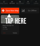
2. In the Offline Maps Menu, tap "Save New Map."
click-here-save-new-map-png.117498

3. Tap inside the "Name" box to give your saved map a distinctive label, if needed
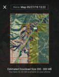
4. The section of map outlined in red is the area that will be saved. Move the outline to the area that you want to save.
117500
5. Choose the map size:
  • 5-Mile Wide High Resolution - smallest area, most detail.
  • 10-Mile Wide Medium Resolution - slightly larger area, slightly less detail.
  • 100 / 150-Mile Wide Low Resolution - largest area, least detail.
6. Tap the "Save" button to begin the download. Wait until this map is done saving before downloading another. The process should take 5 - 10 minutes, depending on your network speed.
117501
 

Attachments

  • click-here-save-new-map.png
    click-here-save-new-map.png
    46.3 KB · Views: 819

onX Hunt

Lil-Rokslider
Joined
Jun 17, 2015
Messages
243
Location
Montana
Here are some additional Tips for your Offline maps. We're always looking for ways to continue to improve our offline maps so if you have any suggestions on how we can make this feature even better, we're all ears.

Tips for saving Offline maps:
  • Turn on the Map Layers you want to save before saving your map, otherwise they will not be available when using the saved map.
  • Save several smaller maps next to each other to stitch together a larger Offline Map.
  • To save smaller property boundaries, choose the smallest map size.
  • Some Layers cannot be saved. Check the Layer's description to see if it's available for Offline use.
  • Before doing anything else in the app, wait for the download to complete.
  • If your screen goes to sleep the download will continue.
  • If you see the "Map Server Busy" error message, wait a few minutes and try saving your map again.
  • Maps are saved into the internal storage of the device. Maps cannot be saved to a removable SD card or other storage medium.
 

TRexF16

FNG
Joined
Aug 22, 2019
Messages
6
Thanks for starting this tutorial series. I joined this forum just to participate in it. As a new OnX member (as of yesterday) I am enjoying learning the app. And as I write this I am doing the offline download for all the areas I know I will be hunting this fall - thanks for the tips!
However I have noticed two things that I hope I am just missing something on, but maybe I am not. Both are related to coordinate format. As a 30 year military veteran I am very used to using various formats. I will say the two most common (in fact, the ones used almost exclusively, in my experience) are Lat-Longs formatted as DD MM.MMMM, verbally called "degrees, decimal minutes" and MGRS - "Military Grid Reference System" (as opposed to UTM, which are similar but not the same). Both of those are the easiest by far to plot on a map, IMO. I don't see any way to choose these as the defaults though other software I've looked at have these as selections. And the other big concern I have is a coordinate should be a three dimensional thing, we need X and Y of course, but Z (Elevation!) is also critical, especially to hunters. I notice I don't get elevation of markpoints or other points of interest like when I tap the screen. When Just navigating, I see that the lat/longs in the bottom of my iPhone 8 display are for the center of the image I am looking at, but the elevation directly below those lat/longs is the elevation of my current position. Right now I am sitting in Tucson, AZ and looking at Flagstaff, AZ, a couple hundred miles north. My current elevation is 2712'. The area I am looking at, and for which I am seeing the correct lat/long, is 7328'. But I have to go to Google Earth to know that. Looking at the OnX display, it looks like it's saying the elevation of the center of the displayed map image is 2712'.
Is there a way I can fix this in the settings? Or is it a glitch in the system?

EDIT:
I'm on the main website for OnX now and I see the above "glitch" is as designed. I copied this from the description of the basic screen display:
"8. Scale bar, Latitude and Longitude and Elevation: Zoom level, GPS coordinates of the center of the map and your current elevation"
I don't know why I would want my elevation as opposed to the elevation of what I am looking at. Interested if I'm in a minority or if others feel that way too.
END EDIT

If you talk to the developers please ask about adding the option for "degrees, decimal minutes" and "MGRS" as coordinate options, and including elevation with all coordinates and waypoints.

Thanks,
Rex
 
Last edited:

TRexF16

FNG
Joined
Aug 22, 2019
Messages
6
Another suggestion -
On the Go to Waypoint feature, put the bearing in degrees (magnetic, not true) instead of "sub-cardinal" (W, NW, N, etc.). If the thought is most users might actually prefer sub-cardinal to magnetic bearing, make it a selectable option on the Map Settings page.
Then add the bearing (in mag heading) to the line when using the Line Distance tool on the map tools tab. The bearing would of course be from the first tap point to the second tap point.
I'm really enjoying getting to know the app, these are just observations to make it even better. I hope they may be of use to your team, though I am confident I'm not the first to have suggested them.
Is there a place on the OnX website where user's can make such suggestions to the developers?

Thanks,
Rex
 

onX Hunt

Lil-Rokslider
Joined
Jun 17, 2015
Messages
243
Location
Montana
Thanks for joining the conversation Rex and we appreciate your input.
At this time for coordinate formats we have Degree Minutes Seconds, Decimal Degrees, and UTM. You can switch between these by pressing the 3 lines in the upper left hand corner then going into the Map Settings. Thanks for suggestions on the other options as well, we know that people use different options so it's good to hear what people prefer so we can look into implementing more options.

As for elevation, we are currently building in more elevation profile information into the app where you can do exactly what you mentioned (drop a waypoint and see the elevation of that waypoint rather than just showing elevation of your location) so be on the lookout for that in the future. At this time the best way to find the elevation is to switch over to the Topographic map and line up the contour lines (the elevation is shown on various elevation lines) with the waypoint you have marked. Again, we understand this is not the smoothest process which is why we are building that other feature.

Lastly, you can orient the map in the direction you are facing by enabling "compass mode" so that it is not always true north. In the bottom right hand corner you will see a circle icon with a crosshair icon in it. If you tap it once, it will bring the map to your location with North up; if you tap it again without moving the map, the icon will change to an arrow and a compass icon will appear in the upper right hand corner, from there whichever direction you are facing will be the way the map is oriented so you can more easily navigate to your waypoints.

Thanks again for all the questions and don't hesitate to reach out if you have more as you get to using the app more!
 

Howell81

FNG
Joined
Feb 28, 2019
Messages
47
Is there a way for my wife to use the ONX app to "track" me while on my hunts? I will be offgrid and don't have money for a garmin to text her. I assume i won't have cell service plus i would prolly keep it off most of time to conserve battery. But if she can see where i move it would help keep her calm. This is my first time away from family for an extented time and my first western hunt.
 

bsnedeker

WKR
Joined
May 17, 2018
Messages
3,019
Location
MT
Is there a way for my wife to use the ONX app to "track" me while on my hunts? I will be offgrid and don't have money for a garmin to text her. I assume i won't have cell service plus i would prolly keep it off most of time to conserve battery. But if she can see where i move it would help keep her calm. This is my first time away from family for an extented time and my first western hunt.

No, a Garmin or some kind of satellite-based communication device is your only option for that. You can rent them from vendors online, I did that last year on my solo hunt. Bought a Garmin this year so I don't have to bother with that.
 

Howell81

FNG
Joined
Feb 28, 2019
Messages
47
No, a Garmin or some kind of satellite-based communication device is your only option for that. You can rent them from vendors online, I did that last year on my solo hunt. Bought a Garmin this year so I don't have to bother with that.


Nuts! O well i guess ill call when i can.
 

TRexF16

FNG
Joined
Aug 22, 2019
Messages
6
And you may be surprised at the coverage you have. Who's your carrier? I get pretty good Verizon coverage in the areas I hunt.
Good luck with the hunt and with the family. Good advice above to not let her stress.
Rex
 

Bluto

WKR
Joined
Jan 16, 2014
Messages
526
Here's an interface question.

I have a few "areas" built as reference for my hunt plan. The problem is, that takes away the ability to click on a road/trail or any other feature within that "area" and get information specific to it. It will only open the pop-up saying the area name and description.

Is there no way to "click through" the area I've defined to get details on objects within it?

For instance, I just built an area around a random spot near town. When clicking on a trailhead symbol, I can't get any trailhead info, only the area I built.

Screen Shot 2019-08-27 at 6.09.20 PM.png
 
Joined
Jul 15, 2019
Messages
73
Following along. Last year was my first year using Onx and it is incredibly useful in the swamps of fl. Being able to navigate flat land via the sat view makes life super simple. THe offline mode works great since most of the time I have no signal in the bigger WMAs. It's really nice that I can send my neighbor a pin (we both have onx) saying I plan to park here and hunt in this area. Eases the wife's mind knowing he has that info if I wasn't to show back up on time.
 
Joined
Apr 9, 2018
Messages
514
Location
Alaska
Does anyone know how to sync your points or pins from the desktop to the micro sd for your gps? Any help would be appreciated!
 

onX Hunt

Lil-Rokslider
Joined
Jun 17, 2015
Messages
243
Location
Montana
Here's an interface question.

I have a few "areas" built as reference for my hunt plan. The problem is, that takes away the ability to click on a road/trail or any other feature within that "area" and get information specific to it. It will only open the pop-up saying the area name and description.

Is there no way to "click through" the area I've defined to get details on objects within it?

For instance, I just built an area around a random spot near town. When clicking on a trailhead symbol, I can't get any trailhead info, only the area I built.

View attachment 118691

At this time, you will need to "hide" the area to click through and see trailhead information. If you go into the My Content Menu, go to the Areas section, and click the check box by the Areas folder or specific area to hide it from the map so you can click on the trailhead for that information then when you want to view that Area again, tap the box so there is a check mark in the box next to it again. I will bug our engineers to get that fixed as personally I have encountered that as well and it is not ideal. Thanks for the feedback!
 

onX Hunt

Lil-Rokslider
Joined
Jun 17, 2015
Messages
243
Location
Montana
Does anyone know how to sync your points or pins from the desktop to the micro sd for your gps? Any help would be appreciated!

To Sync waypoints you marked from onX, you'll need to Export those from the Web Map
This page walks through how to do that - Export from onX

Then you'll upload that file into Garmin Basecamp (free software to view your GPS on a computer) and connect your GPS to the computer and sync it with Basecamp so all those will transfer over.
 

wapitibob

WKR
Joined
Feb 24, 2012
Messages
5,923
Location
Bend Oregon
Don't use the "area" function, use the line function to create a boundary.

If have occasional service, sync your phone app when you do, then your wife can log in to your account on the pc and see where you've been. Not the same but better than nothing.
 

onX Hunt

Lil-Rokslider
Joined
Jun 17, 2015
Messages
243
Location
Montana
Don't use the "area" function, use the line function to create a boundary.

If have occasional service, sync your phone app when you do, then your wife can log in to your account on the pc and see where you've been. Not the same but better than nothing.

Great tips wapitibob!
 

Bluto

WKR
Joined
Jan 16, 2014
Messages
526
At this time, you will need to "hide" the area to click through and see trailhead information. If you go into the My Content Menu, go to the Areas section, and click the check box by the Areas folder or specific area to hide it from the map so you can click on the trailhead for that information then when you want to view that Area again, tap the box so there is a check mark in the box next to it again. I will bug our engineers to get that fixed as personally I have encountered that as well and it is not ideal. Thanks for the feedback!


Many thanks, that will do for now but I do like to utilize the area functions as well. This will definitely get me through until an update though. Cheers!


Wapiti Bob - many thanks for the idea, I'll use that one as well. Pretty simple fix!
 
Top