Jesse Jaymes
WKR
Having just drawn a non res Montana antelope tag I have questions on access. I've hunted antelope in New Mexico and Wyoming. Not certain I ever was put into a situation and dealt with Corner Crossing. I've been told in some states it's legal, and others it's not. And I have been informed Corner Crossing is not legal in Montana. The majority of my question stems from Two Track roads displayed on Onx and other land status mapping apps.
In these wide open desert lands there are two tracks that run almost EVERYWHERE. Gas lines, drinkers, pivots, etc. All exit private and often cross through State or BLM. If these two tracks are not gated and access State.....can you utilize them?
Other than the guys who rent helos and drop in on Ted's state chunks inside his Paradise....are there other clever ways to access these oasis chunks? Could I stay below a High Water mark and walk in if I obtain legitimate access to enter the water?
I will attempt to stick in a few snipped examples:

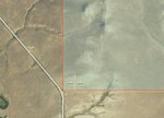
In the above, this road is county maintained. Is this legit access?

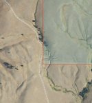
If this two track stems from private but is not gated, is this Access?

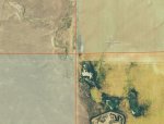
Blue to Blue is NOT access in the above image? I am guessing the mapping boundaries are simply skewed through the App...however if the horizontal road right center was legal access....would you consider it terminating at the right border of State and both State chunks could be legally accessed?
In these wide open desert lands there are two tracks that run almost EVERYWHERE. Gas lines, drinkers, pivots, etc. All exit private and often cross through State or BLM. If these two tracks are not gated and access State.....can you utilize them?
Other than the guys who rent helos and drop in on Ted's state chunks inside his Paradise....are there other clever ways to access these oasis chunks? Could I stay below a High Water mark and walk in if I obtain legitimate access to enter the water?
I will attempt to stick in a few snipped examples:

In the above, this road is county maintained. Is this legit access?

If this two track stems from private but is not gated, is this Access?

Blue to Blue is NOT access in the above image? I am guessing the mapping boundaries are simply skewed through the App...however if the horizontal road right center was legal access....would you consider it terminating at the right border of State and both State chunks could be legally accessed?
