Navigation
Install the app
How to install the app on iOS
Follow along with the video below to see how to install our site as a web app on your home screen.
Note: This feature may not be available in some browsers.
More options
Style variation
You are using an out of date browser. It may not display this or other websites correctly.
You should upgrade or use an alternative browser.
You should upgrade or use an alternative browser.
Why does the resolution on my Onx suck?
- Thread starter Fatcamp
- Start date
wapitibob
WKR
GE will always be better but my 5 mile maps aren't bad.
Ucsdryder
Modern Fuddster
- Joined
- Jan 24, 2015
- Messages
- 7,606
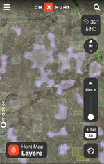
I always assumed they were clouds!Maybe someone can let me know what these purple swatches are?
They’ve been there for months
View attachment 640850
I always assumed they were clouds!
Do purple clouds make purple rain?
Prince would be proud
I believe you have the "roadless areas" layer turned on.Maybe someone can let me know what these purple swatches are?
They’ve been there for months
View attachment 640850
I believe you have the "roadless areas" layer turned on.
That was it! Thx!
dieselchessy
WKR
- Joined
- Apr 21, 2015
- Messages
- 1,090
Do you have the “recent imagery” feature turned on? That often has much less resolution.Google Earth is much clearer. This caused a dangerous situation for me last week.
I don't like it. Google clearly shows the trail out that is not visible with Onx.
Ideas? I updated and it didn't help.
Also, if downloading and using offline you need to download high res, when you actually have good internet and high res displaying.
Maybe you had poor signal at the time
I'm at home now, and it sucks.
Not nearly as good as google earth but definitely adequate.
Connect to wifi?
Sent from my iPhone using Tapatalk
Downloaded map in high resolution evolution connected to wifi. Map sucks and I still can't see the jeep trail I needed.
Marshfly
WKR
Maybe your expectations are simply too high.
I use google earth to scout alongside OnX and mark paths on OnX using Google earth as a guide on the computer prior to leaving the house.
Sent from my iPhone using Tapatalk
I use google earth to scout alongside OnX and mark paths on OnX using Google earth as a guide on the computer prior to leaving the house.
Sent from my iPhone using Tapatalk
Maybe your expectations are simply too high.
I use google earth to scout alongside OnX and mark paths on OnX using Google earth as a guide on the computer prior to leaving the house.
Sent from my iPhone using Tapatalk
Maybe, except a couple years ago we used Onx to find this same trail? For the first time, racing a thunderstorm. I knew it was there but had never walked it.
I specifically remember it being very clear and now it's not visible at all. Maybe the landscape has changed but I think I need to reconsider my options.
Can you take a screenshot of the area and dm it to us? That will help us to take a look on our end and see if we are seeing the same thing you are, or if there is another issue causing your map to be blurry.Maybe, except a couple years ago we used Onx to find this same trail? For the first time, racing a thunderstorm. I knew it was there but had never walked it.
I specifically remember it being very clear and now it's not visible at all. Maybe the landscape has changed but I think I need to reconsider my options.
Bachto
WKR
Is it better on the computer?
Is it better on the computer?
No, it appears to be the same image.
Marshfly
WKR
Maybe, except a couple years ago we used Onx to find this same trail? For the first time, racing a thunderstorm. I knew it was there but had never walked it.
I specifically remember it being very clear and now it's not visible at all. Maybe the landscape has changed but I think I need to reconsider my options.
Trees grow and clouds cover images. What you saw a couple of years ago has almost zero bearing on what you see today.
I think your expectations are just too high. Your only option is to subscribe to multiple mobile satellite imagery services and hope one is great where you are hunting at that time.
Sent from my iPhone using Tapatalk
Similar threads
- Replies
- 24
- Views
- 2K
- Replies
- 2
- Views
- 1K
- Replies
- 70
- Views
- 3K
Featured Video
Latest Articles
- TT#64 Josh Boyd Elk Hunting Strategies for Every Season
- Aaron Davidson of Gunwerks
- TT#63 Dirk Durham’s Art of Elk Calling
- BIG Buck Stories with the Dirty Giants Podcast
- TT#62 Brian Barney Hunting Bulls without Calling
- Hoyt Alpha AX-2 SD Review
- Kuiu Kenai vs Outdoor Vitals Vario Hooded Jacket Review
- Hoyt RX-9 Ultra Review
- Hunting Vampire Bucks & Building an Optics Kit
- Darton Sequel ST2 35 Review

