Navigation
Install the app
How to install the app on iOS
Follow along with the video below to see how to install our site as a web app on your home screen.
Note: This feature may not be available in some browsers.
More options
Style variation
You are using an out of date browser. It may not display this or other websites correctly.
You should upgrade or use an alternative browser.
You should upgrade or use an alternative browser.
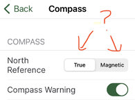
True North or Magnetic North?
- Thread starter cnelk
- Start date
- Banned
- #2
roadrunner
WKR
Doesn't matter, it's just a "calculation" based off of GPS signal.
TJ
WKR
Doesn’t matter, use one or the other.
Next Ridge
WKR
- Joined
- Jun 29, 2020
- Messages
- 376
Magnetic
Dos Perros
WKR
iPhone compasses aren’t accurate or repeatable enough to matter.
Desk Jockey
WKR
- Joined
- Apr 5, 2015
- Messages
- 6,001
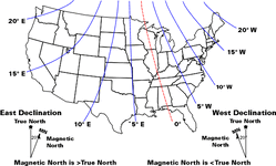
Um. Be careful saying it doesn't matter. Depending on where you are in the us the difference can be 20* or more. if you are navigating with a map and compass that can mean a big difference in what azimuth you shoot vs what you follow.
not to get all mathy, but if for example you are in western Washington and you want to go 1 mile due north, if you took a magnetic compass heading of 0* and walked a mile, you would end up 1/3 of a mile to the east of where you want to be.
if none of that makes sense, google “declination navigation” and read a few of the how to‘s.

Last edited:
NRA4LIFE
WKR
Yes, where I live the magnetic declination is nearly 20 degrees. If you follow magnetic versus true, in 3 miles you'd miss your target by about a mile.
sawsington
FNG
I walk until the blue dot moves. Then that's my direction, easy peasy.
BRTreedogs
WKR
I don't use the map like that.
I attempt to orient the map to the terrain.
Then I walk a ways and make sure I'm heading the correct way I want on the map.
What ever compass direction that is it is.
I attempt to orient the map to the terrain.
Then I walk a ways and make sure I'm heading the correct way I want on the map.
What ever compass direction that is it is.
UncleBone
WKR
- Joined
- Aug 18, 2022
- Messages
- 759
About how I do it too. But Im not charting any super wild courses. I also like to have a reference point other than north. A large peak usually.I don't use the map like that.
I attempt to orient the map to the terrain.
Then I walk a ways and make sure I'm heading the correct way I want on the map.
What ever compass direction that is it is.
roadrunner
WKR
Um. Be careful saying it doesn't matter. Depending on where you are in the us the difference can be 20* or more. if you are navigating with a map and compass that can mean a big difference in what azimuth you shoot vs what you follow.
not to get all mathy, but if for example you are in western Washington and you want to go 1 mile due north, if you took a magnetic compass heading of 0* and walked a mile, you would end up 1/3 of a mile to the east of where you want to be.
if none of that makes sense, google “declination navigation” and read a few of the how to‘s.
View attachment 544638
Not talking about a handheld magnetic compass. Your phone doesn't have a metal needle with poled ends.
The compass app isn't any different than an electronic chart plotter. A GPS lat and long is a GPS lat and long.
If I'm going old school, then magnetic is my preference...
BRTreedogs
WKR
I keep a compass in my emergency kit.
But the objective would to be walking a straight line.
Which ever direction I pick.
But the objective would to be walking a straight line.
Which ever direction I pick.
I believe most US TOPO maps will list the declination at the bottom. I was stationed at Ft. Campbell, KY. We were told not to worry about the declination. And if you look at the above map I may have been around 1* W??Um. Be careful saying it doesn't matter. Depending on where you are in the us the difference can be 20* or more. if you are navigating with a map and compass that can mean a big difference in what azimuth you shoot vs what you follow.
not to get all mathy, but if for example you are in western Washington and you want to go 1 mile due north, if you took a magnetic compass heading of 0* and walked a mile, you would end up 1/3 of a mile to the east of where you want to be.
if none of that makes sense, google “declination navigation” and read a few of the how to‘s.
View attachment 544638
1eyedfatman
FNG
- Joined
- Nov 2, 2014
- Messages
- 11
True north for utm coordinates.
ozyclint
WKR
GPS on magnetic because the compass is magnetic. If they are both the same it eliminates the chance of making a mistake when using the two together.
Just account for declination when required
Just account for declination when required
Similar threads
- Replies
- 13
- Views
- 593
- Replies
- 35
- Views
- 2K
- Replies
- 4
- Views
- 251
Featured Video
Latest Articles
- TT#64 Josh Boyd Elk Hunting Strategies for Every Season
- Aaron Davidson of Gunwerks
- TT#63 Dirk Durham’s Art of Elk Calling
- BIG Buck Stories with the Dirty Giants Podcast
- TT#62 Brian Barney Hunting Bulls without Calling
- Hoyt Alpha AX-2 SD Review
- Kuiu Kenai vs Outdoor Vitals Vario Hooded Jacket Review
- Hoyt RX-9 Ultra Review
- Hunting Vampire Bucks & Building an Optics Kit
- Darton Sequel ST2 35 Review


