Question for the WY draw expert

Jethro

WKR
Joined
Mar 2, 2014
Messages
1,383
Location
Pennsylvania
Touching base again because I'm still dumb. I wish WY would publish some simple things like a map that shows general units highlighted on each species map. I don't believe they have hard copies of regulations any more, but am I reading right that the regulations for this year aren't available until July?

WY Fish and Game

Website totally overhauled last month or so. Has it all.

Edit: ^^you have to click on the green "WY Fish and Game"
 

wytx

WKR
Joined
Feb 2, 2017
Messages
2,312
Location
Wyoming
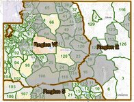
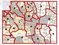
The non gray areas are general, no general pronghorn areas. Gray areas are Limited Quota areas, meaning limited number of licenses for residents and NRs. The quota is the number of licenses given for each area or region for residents and NRs, each separate. Regulations show the number of licenses for each area for both Rs and NRs.
Regions are separated by the red lines.

Click and scroll down to each species and click on them to see licenses numbers(quotas). https://wgfd.wyo.gov/regulations

Edit before you ask: the yellow colored spots are BLM lands-public lands. Green is National forest.
Screenshot 2024-05-22 150609.jpg
Screenshot 2024-05-22 150700.jpg
 
Joined
Feb 21, 2017
Messages
1,808
Location
Colorado
Thank you guys, I was looking for that first map and for some reason couldn't find it! I'll accept my shame. You guys are awesome.
 
Top