OnX only released their Apple Car Play capability about 1-2 years ago. Not sure if GoHunt has released anything yet, but last hunting season they still didn't have that capability. Last year was my first year using OnX through Apple Car play...it was great! I'm impressed how much easier navigating within out-of-state units is now with that feature. The year prior, we were changing camp locations in the middle of the night and looking down at your phone while driving dark unfamiliar roads was slow and not the greatest.
Now, I like using Google Maps for general driving navigation while referencing other apps (OnX or Gaia GPS) on a tablet or phone mounted to the dash. Sometimes Google Maps is finicky in the hunting woods, but generally gives pretty good directions most of the time. Make sure Google Maps is downloaded for offline use (the entire unit). Copy waypoint coordinates from OnX and paste into Google Maps. Sometimes, while offline without service, Google Maps won't find the route with the copied gps coordiantes. So you have to zoom out slightly and select a random point close to your intended destination. Then it should navigate relatively well. At the same time, I like use a iPad mounted to my dash with OnX if Google Maps fails, or if I want to view both maps while driving. Its convenient having OnX on the larger screen in my scenario (small F150 infotainment screen). For main driving routes on unpaved or less established roads, I usually have the route traced in OnX before leaving the house if I end up needing to follow OnX while driving.
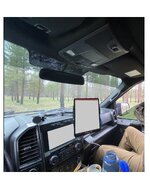
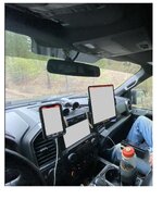
The pictures are my setup. The second pic is obviously overkill but was a good test last year during spring bear season. The mounts are from BulletPoint. I usually run their magnetic attachment for my phone with the Magview plate on the phone case. The iPad is using their tablet clamp, unfortunately a large tablet does tend to slide down a bit if the road is bumpy but otherwise pretty solid. A smaller tablet would be better IMO.