Feedback on district mapping project

cr406

FNG
Joined
Feb 7, 2024
Messages
18
Hi everyone,
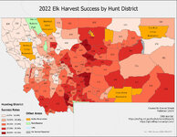
I've been teaching myself GIS for work reasons, and besides online coursework I started a project on my own using MT's publicly available harvest estimate numbers run through some ArcGIS processes to produce maps of HDs paired with an estimated success rate for a given species and year.
Here is an example of what I'm talking about:
Layout.jpg
I know there's some stuff that this map doesn't represent well (type b/antlerless, draw-only districts, etc.), this is more a proof of concept. But what do people on here think about it? Is this at all useful? I'm imagining the target user being either a new-to-hunting resident or a non-resident who doesn't have the money or desire for the catered experience of a guided hunt. Do you feel like this is blowing up the spot? I want to hear those concerns as well, though my initial thought on the issue that this isn't granular enough data to have someone walking into your honeyhole, more to point someone who's dedicated enough to put in the miles in the right direction. That and the fact that this is all public data means it's already out there, though not necessarily in a digestible format.
Is someone already doing this and I've just missed it? seems like a pretty natural extension of the"e-scouting" that OnX and the like are pushing.
If it's something you could use, what else would be useful? I'd like to include district draw odds, publish maps for all species there's reliable data for, maybe start doing other states as well. My thought is if there's enough interest to perhaps start a patreon or substack and see where it goes.

Thanks for the feedback!
 
Joined
Feb 7, 2024
Messages
27
Good job on mapping, I think it could be something useful to see, especially for newer hunters. For my state, I do this manually, with a piece of paper but that’s because I am more aware of the units, so having a map could be useful for new people. Since it is all publicly available data, it wouldn’t be blowing things out of the water in my mind. Success changes on hunting type, road availability, and also changes year to year, so overlaying this kind of data could be useful too. Good luck with the project!
 

Axlrod

WKR
Joined
Jan 8, 2017
Messages
1,499
Location
SW Montana
Welcome to Rokslide. It looks good, my only reservation, is Montana's method of gathering harvest data. They hire private contractors to call you. Each species is a different call. They only call once, and from an unknown #. So if you miss the call or don't pick up, they don't gather a lot of info. I have asked them many times to do an online data collection at the time of tag purchase. Not a ding at all on what you are doing. Good luck.
 
OP
C

cr406

FNG
Joined
Feb 7, 2024
Messages
18
Welcome to Rokslide. It looks good, my only reservation, is Montana's method of gathering harvest data. They hire private contractors to call you. Each species is a different call. They only call once, and from an unknown #. So if you miss the call or don't pick up, they don't gather a lot of info. I have asked them many times to do an online data collection at the time of tag purchase. Not a ding at all on what you are doing. Good luck.
Quality of the data was one of my concerns, thank you for illuminating exactly how it's collected. Do you know about other state's collection procedures?
 

Axlrod

WKR
Joined
Jan 8, 2017
Messages
1,499
Location
SW Montana
Quality of the data was one of my concerns, thank you for illuminating exactly how it's collected. Do you know about other state's collection procedures?
I don't really, but a few years ago I did hear about how another state did it, AZ maybe. And they require the previous year hunting data to be entered online before you can purchase any new licenses.
 
Joined
Feb 7, 2024
Messages
27
Quality of the data was one of my concerns, thank you for illuminating exactly how it's collected. Do you know about other state's collection procedures?
Oregon has a mandatory reporting process, otherwise you will be fined. It’s not a perfect system, but produces relatively good data and they have harvest broken up into antler point categories. They even have some data that is if it was harvested on public or private land, which I find interesting.
 

CMF

WKR
Joined
May 8, 2019
Messages
896
Location
Mississippi
have you seen gohunt.com? They do this, although not exactly in that format.
Their MT info is only listed as #harvested.
With so many general units, how are you getting a harvest percentage? Did they start releasing more data on the units like the number of hunters per unit?
It drives me nuts they only list # harvested on gohunt for MT. It's essentially useless unless you factor it against land area(available) or hunter numbers(which I thought was not available)
 

mustelid_master

Lil-Rokslider
Joined
Mar 29, 2021
Messages
138
Good to see more people messing around with mapping. Montana's data collection sucks. Trappers have to report marten, cats, and otters with a minimum of TRS of harvest. It can all be done online and is fairly seamless, odd for an agency that has a reputation for being technologically inept. I have no idea why they don't do this with big game animals.
This is unrelated to your current project, and I don't know how difficult this would be given that I have no professional experience, but it would be cool to have a viewshed optimization tool in google earth. Make a polygon around a given area you want to glass and GE would tell you the best glassing location.
 

CMF

WKR
Joined
May 8, 2019
Messages
896
Location
Mississippi
but it would be cool to have a viewshed optimization tool in google earth. Make a polygon around a given area you want to glass and GE would tell you the best glassing location.
Onx has has something similar, it shows view shed, and you can move your cursor to various locations to see whats better.
 
OP
C

cr406

FNG
Joined
Feb 7, 2024
Messages
18
have you seen gohunt.com? They do this, although not exactly in that format.
Their MT info is only listed as #harvested.
With so many general units, how are you getting a harvest percentage? Did they start releasing more data on the units like the number of hunters per unit?
It drives me nuts they only list # harvested on gohunt for MT. It's essentially useless unless you factor it against land area(available) or hunter numbers(which I thought was not available)

I divide the harvest by the "hunters" number, which FWP defines as an "Estimate of how many people of this residency hunted in this area." So at least in Montana, it is limited by the fidelity of that information as an input.
 
OP
C

cr406

FNG
Joined
Feb 7, 2024
Messages
18
This is unrelated to your current project, and I don't know how difficult this would be given that I have no professional experience, but it would be cool to have a viewshed optimization tool in google earth. Make a polygon around a given area you want to glass and GE would tell you the best glassing location.
That is definitely beyond my current abilities, but a very interesting idea!
 

CMF

WKR
Joined
May 8, 2019
Messages
896
Location
Mississippi
I divide the harvest by the "hunters" number, which FWP defines as an "Estimate of how many people of this residency hunted in this area." So at least in Montana, it is limited by the fidelity of that information as an input.
can you share a link to the hunters number?
 

CMF

WKR
Joined
May 8, 2019
Messages
896
Location
Mississippi
The reason Gohunt says they aren't giving this number as a percentage is you're looking at all harvest, bull and antlerless for all seasons, gun and archery.
I think there is still value in what you've created and if Gohunt won't provide it, people will look for it elsewhere.
Like you said it's out there already, but the more digestible you make it, the more people will use it, and you would probably see some increase in those units that show significant harvest over others. I don't think the majority of hunters will ever look at this and of those, most won't use it as a singular factor in choosing a unit. Public land percentage, access, grizzlies, etc will also be determining factors.
Make sure you check out Gohunt before you spend time making something that already exists.
 
Top