Determining Road Access

Joined
Feb 2, 2022
Messages
63
What are some good resources or strategies for determining what roads are publicly accessible while escouting? I have been using google maps and forest service maps pulled up on side screens while using onX and if a road is named on google maps or shown for vehicle use I assume it’s accessible but there were still a few surprises on my last trip where other roads ended up being open and changed my game plan. Any other resources or things to look for?
 
Joined
Apr 18, 2019
Messages
1,623
Will the county or DOT people know about Forest service roads? I’m taking those Class II roads that are maybe 75% passable with a truck you don’t want to scratch or beat the crap out of.
 

TSAMP

WKR
Joined
Jul 16, 2019
Messages
1,447
Forest service dedicated maps. I've found the seasonal closures aren't always indicated or current on your GPS mapping SW such as onX.
 
Joined
Feb 3, 2022
Messages
94
Location
SW MT
Only real way is to scout yourself. I know it sucks but there’s no guarantee the warden or DOT have been to the road and OnX / maps are OFTEN incorrect. It’s actually shocking just how wrong those scouting tools can be.

When I have an area I want to go I find at least 3 access points then start at the easiest and work my way down. Normally if it takes the third access point to actually get in there it means there’s pretty good hunting! 😉
 

Burg1

FNG
Joined
Sep 26, 2022
Messages
11
Only real way is to scout yourself. I know it sucks but there’s no guarantee the warden or DOT have been to the road and OnX / maps are OFTEN incorrect. It’s actually shocking just how wrong those scouting tools can be.

When I have an area I want to go I find at least 3 access points then start at the easiest and work my way down. Normally if it takes the third access point to actually get in there it means there’s pretty good hunting! 😉
This is pretty accurate. Boots on the ground is really the only way to know unfortunately. However a call to the game warden never hurts
 

BCSojourner

Lil-Rokslider
Joined
May 24, 2018
Messages
201
Location
Kremmling, CO
As noted in previous post, the USFS MVUM maps for the area that you are interested in will be the best source of access. These maps should have use designations (open, limited, closed) as they apply to OHV use and they are the definitive (and legal) source for authorized public access. That being said, although they may also note the type of route (i.e., 4WD, ATV, UTV, etc.) they will not tell you everything you might want to know about the route. Many of the 4WD routes open to full-size 4WD routes are high clearance type, very potholed, and rough and may warrant use of an ATV or UTV to get where you want to be in a timely manner. The best method for checking out a route is still actually driving it. Don't trust Google Earth to give you accurate information about the true nature of a route. A phone call or two to the local recreation staff at the Ranger District (USFS) or Field Office (BLM) will also pay big dividends for acquiring useful information about area routes. If you are planning a summer scouting trip, keep in mind that, due to high snowpack condition, USFS and BLM travel routes at many forest and field office areas in the Rocky Mt West will likely experience high runoff and late snowmelt this year so it is likely that many will not be fully open and passable until July.
 

basket8

FNG
Joined
Aug 9, 2021
Messages
33
Location
Wyoming
What are some good resources or strategies for determining what roads are publicly accessible while escouting? I have been using google maps and forest service maps pulled up on side screens while using onX and if a road is named on google maps or shown for vehicle use I assume it’s accessible but there were still a few surprises on my last trip where other roads ended up being open and changed my game plan. Any other resources or things to look for?
most counties have a tab on their website with a county road map. Some are very nice GIS interactive maps, others just a PDF. These have been extremely helpful in the past. BLM also has a lot of easements across private to access BLM parcels, these wont show up on county road maps or onx. Best to contact local BLM office and ask if they have any in the area you are looking.

Happy hunting.
 

Firedad

FNG
Joined
May 21, 2022
Messages
57
If they are FS roads you are curious about, contact the local engine and they’ll have access info you need. Including road conditions
 

Poser

WKR
Joined
Dec 27, 2013
Messages
5,033
Location
Durango CO
If in Colorado, the COTREX app is very useful. It will even list the closure dates.

Came to say the same. This map is invaluable.

Also, picking up off-road guidebooks for the state or area you’ll be hunting can be useful as well.

Instead of calling a game warden to ask about various road access, join various regional off-roading community FB groups and similar. You’ll get much more precise information.
 

Beendare

WKR
Joined
May 6, 2014
Messages
8,247
Location
Corripe cervisiam
The FS puts out Motor Vehicle Use Maps. They are about the most accurate on their land.
Bingo…

The problem; slob hunters disrespect these closures regularly. I’ve seen it in every western state hiking in a road and had Quads, motorcycles, vehicles pass me…

I’ve had many GW tell me to get the plates or a photo and please report. A few spots in MT it looked like more traffic driving around a locked gate than out on the highway.
 

wapitibob

WKR
Joined
Feb 24, 2012
Messages
5,365
Location
Bend Oregon
MVUM for forest
BLM map for BLM
County map for county
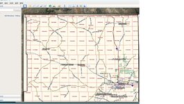
You can compare the county map to onX roads if you use onX and can then create your one onx road layer if you wanted. You can also add the county maps to GE with a little work.

Untitled.jpg
 

wytx

WKR
Joined
Feb 2, 2017
Messages
2,057
Location
Wyoming
Road conditions change year to year, especially on those smaller side FS roads.
Been down some like you described but instead of a hole it was trees growing too close to the narrow road.
No way to really know without driving them, atvs work best for that we've found.
 
Top