Yes. You download maps you want to use and after that all you need is GPS service. I highly recommend doing that all the time because if you do not and your cell service is spotty, your tracking can lock up. In offline mode (downloaded maps) you never have an issue.Does this Gaia service require using a cellphone? I like that my separate GPS device just has the OnX chip inserted into it and so I don't have to use my phone for that stuff. Does this Gaia service have an offline option like that? Where you can DL what you need and be able to run it and work with it without cell service and without using a cellphone?
Navigation
Install the app
How to install the app on iOS
Follow along with the video below to see how to install our site as a web app on your home screen.
Note: This feature may not be available in some browsers.
More options
Style variation
You are using an out of date browser. It may not display this or other websites correctly.
You should upgrade or use an alternative browser.
You should upgrade or use an alternative browser.
Buh Bye OnX .... Hello GAIA!
- Thread starter cnelk
- Start date
As I said I do not want to use my phone for that. I want to use my handheld GPS for those purposes, so I'm not burning battery on the phone. (I typically walk around with it on Airplane mode since never cell-service in the areas I go)... So I'm interested to know if it can be used in that same way... downloaded... perhaps onto a little microSD card and shoved into my eTrex 30?Yes. You download maps you want to use and after that all you need is GPS service. I highly recommend doing that all the time because if you do not and your cell service is spotty, your tracking can lock up. In offline mode (downloaded maps) you never have an issue.
Sorry, misunderstood the question.As I said I do not want to use my phone for that. I want to use my handheld GPS for those purposes, so I'm not burning battery on the phone. (I typically walk around with it on Airplane mode since never cell-service in the areas I go)... So I'm interested to know if it can be used in that same way... downloaded... perhaps onto a little microSD card and shoved into my eTrex 30?
Brendan
WKR
Want to make sure you're understanding it: You do not need cell service to use Gaia, or any of these apps. Phone can remain on airplane mode the entire time and doesn't burn any battery in the background.As I said I do not want to use my phone for that. I want to use my handheld GPS for those purposes, so I'm not burning battery on the phone. (I typically walk around with it on Airplane mode since never cell-service in the areas I go)... So I'm interested to know if it can be used in that same way... downloaded... perhaps onto a little microSD card and shoved into my eTrex 30?
You download maps at home, on wifi, with the phone charged up (or on cell in the field if you want). You go hunting, leave the phone on airplane mode, GPS and downloaded maps continue to work fine with minimal battery use when you need them. I basically open the phone look at the app for 30 seconds or however long (topo, satellite, land owndership, navigation, whatever), put it back to sleep. Lasts quite a while. I don't even carry a dedicated GPS anymore, especially when I have my Inreach and my watch as backups.
How much was the subscription? Is it still blowing OnX out of the water???Ohhh Man.
Just for sh!ts and giggles, I purchased Gaia to give it a try (for a lot less $$$ than OnX!)
So far it blows OnX outta the water.
I can scroll thru ALL 50 States, see where public land is at, land ownership, send waypoints to friends, on and on!
I typically hunt multiple states each year and being able to have the same APP features throughout each state is so nice!
No more BETA 3D updates in September like OnX did - that was a deal breaker.
How much is the subscription? Is it still better than OnX?Ohhh Man.
Just for sh!ts and giggles, I purchased Gaia to give it a try (for a lot less $$$ than OnX!)
So far it blows OnX outta the water.
I can scroll thru ALL 50 States, see where public land is at, land ownership, send waypoints to friends, on and on!
I typically hunt multiple states each year and being able to have the same APP features throughout each state is so nice!
No more BETA 3D updates in September like OnX did - that was a deal breaker.
WyoKid
WKR
- Joined
- Aug 6, 2019
- Messages
- 391
Posting this response for the benefit of all - someone had a question about accessing all the layers, such as migration routes or wildfires. In short, you must have the Premium to access the full maps and layers for all states and hunt areas.
Right now there is a Gaia discount code on their website - $36 for the Premium for a full year.
Right now there is a Gaia discount code on their website - $36 for the Premium for a full year.
Once you have the premium, click in the top right corner to open the layers. You need the premium to access all the layers.It really depends on your level of membership - there are 3 levels: Free, Basic Membership or Premium Membership.
I started out with the Free but changed to the basic and then Membership premium within 6 months - if you already have the basic membership, Gaia let's you upgrade.
Get the Premium for $36 (there is discount code with Gaia right now)
Gaia GPS Membership with Outside+
Outside+ brings you all of the world’s best exploration maps plus a deep catalog of outdoor content to fuel your adventures. Outside+ gives members best-in-class storytelling, online outdoor education courses, gear and trip reviews, premier film and tv content, and more.www.gaiagps.com
For $36 a year, you get all states, all hunting, migration, snow fall, wildfires, slope, roadless areas, etc. You can also fully download any map or layer. A bargain IMHO. I got fed up with onX and the cost and add on fees, which Gaia bundles with the premium.

Free versus Premium Membership
What's included in a Premium Membership to Gaia GPS? Unlock Gaia GPS's potential with a Gaia GPS Premium Membership. Learn about the added features and maps that come with a Premium Membership be...help.gaiagps.com
Here is a basic run down of the 3 services:
With a free download, you can drop waypoints, plan routes, record tracks and follow your current location. You're limited to the default map source (Gaia Topo), and you cannot download maps to use when offline and out of service on Free.
With the basic ($17) you get Free + over 50 base maps that spans worldwide topo, road, and satellite maps. You can download maps for offline use (however, downloading layered maps requires a Premium Membership).
With Premium ($36), you get Free + Basic + the full Gaia GPS maps catalog (international, all states, all hunting maps, etc.) with over 250 maps and overlays:
NatGeo Trails Illustrated
Backroad Mapbooks Canada
ESRI World Imagery
France IGN
SwissTopo
NeoTreks US Topo
US Hunting Maps (GMUs, private land, public land, others)
With Premium you can fully use and download all layered maps. Apply any overlays to any map, such as hill-shading, contour lines, slope angle, migration, snow fall, wildfire maps, off road vehicle maps, wilderness maps, all trail maps, bedrock layers, tribal lands, cell coverage, etc.
Gaia has a discount code for the Basic Membership and Premium Membership.
Gaia GPS Membership with Outside+
Outside+ brings you all of the world’s best exploration maps plus a deep catalog of outdoor content to fuel your adventures. Outside+ gives members best-in-class storytelling, online outdoor education courses, gear and trip reviews, premier film and tv content, and more.
Hope this helps.....
Attachments
Huntingfanatic
FNG
- Joined
- Jan 21, 2013
- Messages
- 57
Used Gaia for several years now. Love it. Especially having all the states. I even used it today to help my wife who is a real estate agent find out who owned a residential lot that was for sale . I just used the private layer and there it was
WyoKid
WKR
- Joined
- Aug 6, 2019
- Messages
- 391
Still on sale.... cannot beat the price and more features than onX....and spends less on marketing and more on features for the user.How much was the subscription? Is it still blowing OnX out of the water???
How much is the subscription? Is it still better than OnX?
Attachments

CLB38
FNG
This has been an immensely helpful. I’ve been considering getting a mapping tool and the advertising budget had worked and I was about to buy onx. Gaia sounds like a superior option, and I’m glad I stumbled across this thread!
I purchased Gaia on the Apple App store. I turned off the auto renew. It expires this week. I was out in the middle of nowhere on a 100 year old road and Gaia did not have it listed. I found it to be quite inaccurate. I am considering CalTopo for the upcoming year
Brendan
WKR
Many of the layers on Gaia are from Caltopo. Might want to consider that...I purchased Gaia on the Apple App store. I turned off the auto renew. It expires this week. I was out in the middle of nowhere on a 100 year old road and Gaia did not have it listed. I found it to be quite inaccurate. I am considering CalTopo for the upcoming year
And, don't think Caltopo works off grid does it?
eaglemountainman
WKR
I took my first foray into hunting GPS technology today and subscribed to Gaia this morning. Now, can anyone recommend a good tutorial for Android online for this analog old man?
WyoKid
WKR
- Joined
- Aug 6, 2019
- Messages
- 391
Gaia has some good tutorials on uTube and their website. But, out is pretty intuitive - just play around with layers, clicking on different icons, etc.I took my first foray into hunting GPS technology today and subscribed to Gaia this morning. Now, can anyone recommend a good tutorial for Android online for this analog old man?
dla
WKR
I bought OnX for $20 for Idaho. It works very well. I'm just a hunter/fisherman/camper that shares data with one other OnX user. I'm probably not a power user capable of appreciating the capabilities of gaia (for more money).Still on sale.... cannot beat the price and more features than onX....and spends less on marketing and more on features for the user.
About the only thing I would like is underwater maps of lakes and reservoirs, and updated images in winter for ice fishing. I know I'm dreaming.
eaglemountainman
WKR
Thanks for the reply. I've seen the YouTube tutorials and went catatonic trying to watch and understand them. I suppose at some point I'll absorb some of that, but right now, all I'm really interested in is how do I bring up the layer that shows public from private lands. That is really the primary reason I invested in the app. I want to know that the land I'm standing on is legal. If someone could point me in the right direction with that, I'm sure that down the line Ill pick up on some of the other features at my own pace. Thanks to anyone who can help me out.Gaia has some good tutorials on uTube and their website. But, out is pretty intuitive - just play around with layers, clicking on different icons, etc.
BBob
WKR
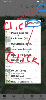
This is for iOS, I'm sure android would be similar. Hit the layers icon on upper right of screen. At bottom hit + Add map layers. At this point I believe you select Feature/Weather, scroll to find and then select Private Land (US) and hit the + add in upper right corner. I think it will now end up on the inactive list in your layers, if so hit the up arrow and it will move it up to your active layers list. Once it's in the active layers you can now use the slide bar to change the transparency of that layer on the map.Thanks for the reply. I've seen the YouTube tutorials and went catatonic trying to watch and understand them. I suppose at some point I'll absorb some of that, but right now, all I'm really interested in is how do I bring up the layer that shows public from private lands. That is really the primary reason I invested in the app. I want to know that the land I'm standing on is legal. If someone could point me in the right direction with that, I'm sure that down the line Ill pick up on some of the other features at my own pace. Thanks to anyone who can help me out.
Warning: If you enable too many ACTIVE layers and attempt to fully zoom in on the map the app will likely crash. I've been over this with GAIA and it's not an app fault but some sort of memory limit on the phone (iOS). It only happened to me because I had so many ACTIVE layers. I'd use the slide bar to turn them on and off instead of making them inactive.
Last edited:
Brendan
WKR
I bought OnX for $20 for Idaho. It works very well. I'm just a hunter/fisherman/camper that shares data with one other OnX user. I'm probably not a power user capable of appreciating the capabilities of gaia (for more money).
About the only thing I would like is underwater maps of lakes and reservoirs, and updated images in winter for ice fishing. I know I'm dreaming.
Gaia is a lot less money than OnX if you consider that you should be comparing to the $100 version of OnX that gives you every state.
If you only need ID, that makes more sense though.
eaglemountainman
WKR
Thanks BBob! It was a bit different than you described, but led to an AH-HA moment. Appreciate the help, man. Thanks again.This is for iOS, I'm sure android would be similar. Hit the layers icon on upper right of screen. At bottom hit + Add map layers. At this point I believe you select Feature/Weather, scroll to find and then select Private Land (US) and hit the + add in upper right corner. I think it will now end up on the inactive list in your layers, if so hit the up arrow and it will move it up to your active layers list. Once it's in the active layers you can now use the slide bar to change the transparency of that layer on the map.
Warning: If you enable too many ACTIVE layers and attempt to fully zoom in on the map the app will likely crash. I've been over this with GAIA and it's not an app fault but some sort of memory limit on the phone (iOS). It only happened to me because I had so many ACTIVE layers. I'd use the slide bar to turn them on and off instead of making them inactive.
tdhanses
WKR
- Joined
- Sep 26, 2018
- Messages
- 6,080
The $20 you spent gives you 1 state, the $36 for Gaia gives you all states, so you’re not really comparing pricing apples to apples, the ONX equivalent is $99.I bought OnX for $20 for Idaho. It works very well. I'm just a hunter/fisherman/camper that shares data with one other OnX user. I'm probably not a power user capable of appreciating the capabilities of gaia (for more money).
About the only thing I would like is underwater maps of lakes and reservoirs, and updated images in winter for ice fishing. I know I'm dreaming.
Similar threads
- Replies
- 29
- Views
- 21K
- Replies
- 41
- Views
- 21K
- Replies
- 7
- Views
- 7K
Featured Video
Latest Articles
- Unlock Precision Shooting: Master Your Hunting Game with Competitive Insights
- Topo Topper Rincon Review
- Tony Trietch on Big Mule Deer, Desert Bulls & Western Hunting Evolution
- The Right to Hunt & Fish Colorado (and North America)
- Mastering New Zealand’s Mountain Hunts: Challenges and Rewards
- Iron Will Turkey Broadhead Review
- Nevada Mule Deer & The Trade-Offs in Wildlife Management
- Spartan SpringBok Bipod Review
- All About Pronghorn & Hunting Big Ones with Chance Marshall
- Bill Vanderheyden Debunks Myths About Long-Distance Accuracy