Buh Bye OnX .... Hello GAIA!

wapitibob

WKR
Joined
Feb 24, 2012
Messages
5,921
Location
Bend Oregon
As I said I do not want to use my phone for that. I want to use my handheld GPS for those purposes, so I'm not burning battery on the phone. (I typically walk around with it on Airplane mode since never cell-service in the areas I go)... So I'm interested to know if it can be used in that same way... downloaded... perhaps onto a little microSD card and shoved into my eTrex 30?
buy the onX sd card for the state you are hunting.


WyoKid

WKR
Joined
Aug 6, 2019
Messages
330
GAIA just added 3D mapping on the desktop. Button and slider in the lower right of the screen. Works on thw couple maps that I tried.

Sent from my SM-N986U using Tapatalk
That is awesome....GAIA is always upgrading and adding features while keeping the cost reasonable for the standard working guy/gal. I am glad I went with GAIA and dropped the others.
 

WyoKid

WKR
Joined
Aug 6, 2019
Messages
330
The $20 you spent gives you 1 state, the $36 for Gaia gives you all states, so you’re not really comparing pricing apples to apples, the ONX equivalent is $99.
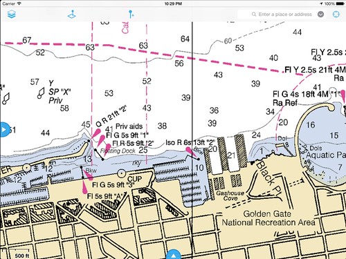
And, for $36, GAIA does have NOAA, marine and hydrography layers.


pyle762

FNG
Joined
Nov 19, 2020
Messages
32
Location
AZ
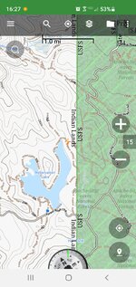
Another GPS that is pretty awesome is Back Country Navigator. That is what I use. It is right around what the price of Gaia is for the subscription. (Sorry iOS users...only for Android). The awesome thing about it is that each state has a download, and you can download your entire state for offline use. The AZ/NM map package is 367 MB. The downloads are free. You can also download the other regular maps and sat images like Gaia.

The map has topo lines spaced at 20 meters. It has most trails on it, along with almost all the dirt roads. It has all the tanks and springs marked. You can get overlays on it for not too much. The AZ overlay of all the public/private lands cost an extra $10. Some states have hunting unit boudry overlays that you can purchase.

Here is an example of the free map


Attachments

  • Screenshot_20210226-162717_BackCountry Navigator PRO.jpg
    Screenshot_20210226-162717_BackCountry Navigator PRO.jpg
    236.1 KB · Views: 38
Last edited:
Joined
Jan 3, 2020
Messages
1,032
Location
Becker Ridge, Alaska
I've never used ONX...but I do like GaiaGPS.
For interior Alaska, they show cell phone tower coverage, wildfire perimeters, game management units,
high res imagery, recent imagery, topo maps, ownership parcels, etc.
 
Joined
Nov 6, 2017
Messages
586
Location
WA
Between my OnX being 110% useless (every map was just brown blobs) for all of 2020 season and this thread, I'm dumping them tonight and going with Gaia.

Very informative, thanks all.
 
Joined
Feb 16, 2021
Messages
12
Location
Arkansas
I just purchased OnX a couple months ago for the first time. I will have to look at GAIA now. Thanks for the info.
 

buggz

FNG
Joined
Nov 25, 2020
Messages
99
Location
Georgia
Was thinking of onX, now purchased Gaia.
Ordered Dual XGPS160 SkyPro Bluetooth GPS Receiver to use with my non-cellular iPad Pro.
What are some good detailed satellite and topo layers to use?
 

maverick

Lil-Rokslider
Joined
Apr 5, 2012
Messages
193
Location
Oregon
Was thinking of onX, now purchased Gaia.
Ordered Dual XGPS160 SkyPro Bluetooth GPS Receiver to use with my non-cellular iPad Pro.
What are some good detailed satellite and topo layers to use?
Look back to a post from Brendon on Jan. 31st 2020. It tells you how to add google earth imagery as a layer. When you download an area there is a slider at the top to choose the detail level.

Sent from my SM-N986U using Tapatalk
 

pyrotechnic

Lil-Rokslider
Joined
Nov 7, 2019
Messages
249
Has anybody else had issues with stupid slow map download speeds with Gaia?

Between the extremely slow download speeds, the ridiculous file sizes (gigabites for hunting district overlays), and the inability of the app to download in the background I won't be renewing my subscription when it expires.
Customer service was less than helpful aka "keep the app in the foreground when downloading maps"

I also had issues with well used forest service roads not being listed on gaia, my buddy with onx did have them on his app.

I've used locus pro extensively and (to me) there's no comparison in ease of use and file size for their proprietary topo maps are much smaller. Locus pro doesn't have a good option for statewide public land boundaries or I wouldn't have even bothered with trying Gaia.
 

cdods

FNG
Joined
Aug 13, 2017
Messages
31
Location
Cheyenne, Wyoming
I tried GAIA next to Onx this year. I loved a lot of the Features of GAIA, I had on glaring problem with GAIA, though. I fond numerous areas where the GAIA maps were not accurate with the public land. All were BLM areas and I confirmed this through the Wyoming Game and Fish website. As cool as GAIA is I rely on my GPS app quite a bit during antelope and some of my mule deer areas.
 

Erict

WKR
Joined
Jun 28, 2020
Messages
673
Location
near Albany, NY
Cdods - What do you mean by "glaring problem" and "not accurate with public land"? What layer(s) in particular did you find questionable?
 

JBrew

Lil-Rokslider
Joined
Jun 6, 2019
Messages
253
I much prefer the layout and functionality of OnX, but GAIA hooks up to CarPlay, which has come in pretty handy on the truck screen. OnX says they are looking into adding it...hope they do.
 

slick

WKR
Joined
Feb 13, 2014
Messages
1,798
Except Gaia has more maps which could or couldn’t be useful to you depending on what you need.

And their topographic is 100x better than OnX


Sent from my iPhone using Tapatalk
 
Top