Weather in mountains vs closest town

Neckbone

Lil-Rokslider
Joined
Sep 21, 2022
Messages
242
How do you all go about estimating the weather in the mountains you will be hunting in?

The closest town to where I will be hunting in western Wyoming is 10 miles as the crow flies at 6500 ft in elevation. I will be around 9500ft.

in your experience how does that translate to the higher elevation mountains?
 
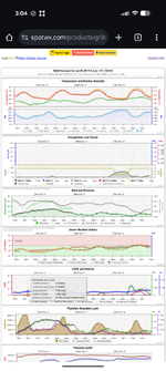
I have been using spotwx.com over the last year with great success. You can pick between US or Canadian Weather model and it gives all sorts of detailed weather data for the elevation and location in question. You can change units once you select the model and forecast you are interested in.
 
Expect a 25–30-degree difference in temp between those two elevations. Wind can vary greatly also. If you are staying overnight. I live at 5600 feet. I went up to 10.3k on Thursday and there was a 25-degree temp drop, and a 20-mph sustained wind increase. This was in the afternoon before sundown. Mountain weather has a mind of its own. And it changes quickly. Pack plenty of gear to stay warm if you are staying overnight. Or, drop back down in elevation to camp and hike back up in the morning.
 
How do you all go about estimating the weather in the mountains you will be hunting in?

The closest town to where I will be hunting in western Wyoming is 10 miles as the crow flies at 6500 ft in elevation. I will be around 9500ft.

in your experience how does that translate to the higher elevation mountains?
For temp it’s 3-5 deg per 1000 ft. So 9-15 deg less
 
Tagged. My plan is to monitor the nearest ski resort this fall.

A couple years ago we camped (six miles via BLM road from the nearest gravel public road) one night and 2" of snow was forecasted. We woke up in the middle of the night to 6" and it was closer to 12" by the time it stopped. Made for an interesting story/day/memory but a mistake I won't likely make again.
 
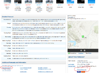
Some NOAA forecast offices publish backcountry/mountain forecasts. You can try poking around here. They all publish forecast discussions every 12 hours, which will usually tell you a lot more than the graphic for the town forecast.

1757968843964.png
 
Here is a screenshot of the details from spotwx (example from a random location on MT. Hood) that gives details at the elevation you are interested in.

Another option is also Mountain-Forecast that would give you rough elevation band weather data for certain peaks in the area of interest.
6589.png
 
Mountain-forecast.com has been pretty accurate the last few years for me.

 
Mountain-forecast.com has been pretty accurate the last few years for me.


I downloaded this app and got the paid version to get a longer forecast window.

I'm liking the numbers it's showing me thus far, though obviously there's no guarantee they'll be right.

We've hit the timeframe where I am looking at the weather in CO more than I look at it here at home. It's almost time. :)
 
I’m willing to bet 90% or more of the online weather services and apps, including those mentioned above, are using NOAA/NWS data. I’d rather bypass someone’s interpretation of that data and get the information direct from the source, I’ve found it’s more accurate. To get an backcountry forecast simply tap the map that’s shown on the NOAA site for the area in question and NOAA will provide a forecast for that region (this was mentioned above). It’s not shown in the picture but immediately below the map, you can scroll down and the elevation and other information is provided.

https://forecast.weather.gov/MapClick.php?lat=40.7274&lon=-115.4805

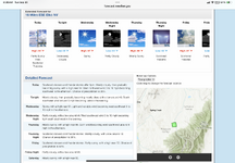
Forecast for a small town near the Ruby Mountains in Nevada:

IMG_3623.png

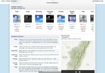
Clicked on the top of the range (see the pin has moved) and a mountain forecast is provided:

IMG_3622.png
 
I’m willing to bet 90% or more of the online weather services and apps, including those mentioned above, are using NOAA/NWS data. I’d rather bypass someone’s interpretation of that data and get the information direct from the source, I’ve found it’s more accurate. To get an backcountry forecast simply tap the map that’s shown on the NOAA site for the area in question and NOAA will provide a forecast for that region (this was mentioned above).

https://forecast.weather.gov/MapClick.php?lat=40.7274&lon=-115.4805

Forecast for a small town near the Ruby Mountains in Nevada:

View attachment 943331

Clicked on the top of the range (see the pin has moved) and a mountain forecast is provided:
I can be fiercely stubborn about doing things myself, but I figured the $3 per month I'm paying for a month or two of weather forecasts adjusted to the elevations I'll actually be at, are worth it.

I don't expect them to be perfect, of course. There's a fairly good sized peak maybe 10 miles from where we intend to hunt, and it's worth $3 to have a forecast for that peak, and also for the mid-slope elevation that is close to what we will likely encounter.

Also - I got both. I have the NWS Clime app also. I also can get daily wx through the InReach, but I really want an idea of what the next 2-3-4 days look like before I commit to hiking camp into a spot off the road.
 
I usually just check the forecast for 2 towns on different sides of the area I'm headed, do a rough elevation calculation for for the temps and factor more intensity for any potential weather.
 
Back
Top