National Forest Tree Markings

SMOKYMTN

WKR
Joined
Dec 18, 2017
Messages
929
Location
Smoky Mountains, NC
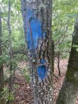
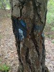
I hunt NF land exclusively here in NC so I typically know the various tree markings however this was new to me. These were sprayed blue on the tree where the tree had been notched. I typically see this with the red boundary lines out here. It started at the top of the ridge and came down to the private boundary, a total of about a mile. I have access to the private land as well, so I followed it and it dead ends at the gentlemen’s driveway. He thought it could have been trespassers but I don’t think so. This was done in nearly identical fashion to other USFS tree markings and is 90% on government land, 10% on his.

I wondered if it could either be a biological survey or a SAR route (I know I’m reaching) but I’ve hypothesized everything, and couldn’t find a definitive answer online.

As you can tell by the picture, this was done some years ago.

Thanks in advance.
 

Attachments

  • A94B7857-5425-43F2-B0A9-C907D5F02D4C.jpeg
    A94B7857-5425-43F2-B0A9-C907D5F02D4C.jpeg
    469.3 KB · Views: 86
  • C7D1DD8D-9B4E-4CA7-A73F-CA728D525CC9.jpeg
    C7D1DD8D-9B4E-4CA7-A73F-CA728D525CC9.jpeg
    516.9 KB · Views: 83
I would say survey markers as well, especially since some of the trees are also already notched. They marked out the business/farm assessed tax property boundaries with blue paint at the resort I previously worked at a couple years back. Prior to that I was under the impression that the blue paint was only for marking trees to be removed.
 
I initially thought survey, but not anymore because there is no survey pattern or boundary. I could be wrong though but it literally splits the gentleman's private property AND goes right up the middle of USFS land. I have found survey markers in the area, which typically are red metal markers and/or red marks on the trees. Also, of note, they did the same thing with the boundary markers in terms of notching the tree.

Another reason I don't believe this to be a survey marking is because they can be found roughly every 10 yards in a line, spanning nearly a mile. Most survey markings I've seen are not that frequent and typically have a boundary or some sort of pattern associated with it. This is simply as random as it gets.

I did wonder if they were marking them for removal, but the USFS wouldn't mark trees on Private Land UNLESS they would be looking to gain access through it, but he hasn't been approached about such.

I may call my local office and see if they can point in the right direction. I know he wants to know as he thought it was trespassers, but trespassers wouldn't be that brazen and the pattern of notching and marking trees is too similar to that used by the USFS for marking boundaries.
 
In virginia/west virginia alot of hiking trails are marked with blue signs and blue paint

This resembles more of a trail, than anything BUT there is no trail defined or mapped, nor does it explain why it crosses over to private property.

I've submitted an email. Thanks for the input everyone.
 
They are possibly gonna cut a trial. That’s what they do in Virginia’s NF.


Sent from my iPhone using Tapatalk
 
Likely a cut boundary. Look right, see trees.....look left, no more trees.

Thats a clear cut in it's infancy in the nw.
 
It looks to me like a boundary marking. The scar on the, I think, Chestnut Oak is not fresh. The hack on the pine might be as it looks like some fresh sap oozing out. Are you sure it goes onto private? I looks like whoever marked it thought they were marking an established boundary.
 
Likely a cut boundary. Look right, see trees.....look left, no more trees.

Thats a clear cut in it's infancy in the nw.

agreed here in the NW that’s a cut boundary. First sign is survey tape in trees then in the next year or two paint and then in a matter of 2-3 weeks giant clear cut.
 
Back
Top