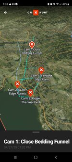
I've been getting some real promising results from using ChatGPT to analyze satellite imagery to build hunt plans for the upcoming deer season. I've been able to provide gps coordinates of an area I'm interested in and it's been able to accommodate for topography, thermals and deer behavior to develop a route a deer might follow. It takes account for bedding and feeding areas, and has listed good spots for setting trail cams. I've also been able to find new spots that fit in specified variables like on public land, with an hour of my house, edge habitat and with a certain distance of a water source. This is all very academic at this point but shows some interesting potential. Thought I'd share. Here's an example path it generated from real satellite imagery, exported a gpx file that can be imported into OnX. Pretty mind blowing. The perpendicular lines show thermal paths
Navigation
Install the app
How to install the app on iOS
Follow along with the video below to see how to install our site as a web app on your home screen.
Note: This feature may not be available in some browsers.
More options
Style variation
You are using an out of date browser. It may not display this or other websites correctly.
You should upgrade or use an alternative browser.
You should upgrade or use an alternative browser.
ChatGPT virtual scouting assistance
- Thread starter Bidwell
- Start date
displacedtexan
WKR
- Joined
- Feb 12, 2022
- Messages
- 2,815
Promising?
Gonna have ChatGPT sight in your rifle for you too?
Gonna have ChatGPT sight in your rifle for you too?
mustelid_master
Lil-Rokslider
- Joined
- Mar 29, 2021
- Messages
- 273
I have though about the applications for feeding whole units into AI and having it indentify basins of interest, larger scale scouting. This looks interesting
Mule3006Elk
WKR
Just for kicks I put in my honey hole coordinates and it did not provide any useful data. Spit out a tremendous amount of general data. Nothing that correlates to my experience with boots on the ground.
I get it. I have conflicting feelings about using tools like this, but I'm also just curious, and this is more of a curiosity at this point.Promising?
Gonna have ChatGPT sight in your rifle for you too?
Not surprised by that. Nothing can compare to real world experience. I did ask it to locate an area with certain parameters in the national forest area I hunted in last year and this spit out gps coordinates with a half mile of my area last year. May have just been luck or coincidence but it was shocking to see. Given the hundreds of thousands of acres it searched.Just for kicks I put in my honey hole coordinates and it did not provide any useful data. Spit out a tremendous amount of general data. Nothing that correlates to my experience with boots on the ground.
I wanted to note that I also used this to do ballistic comparisons between various cartridges and bullet weights as well. Pretty cool to be able to generate a custom dope chart in about 30 seconds or compare say a 308, 6.5cm and 270 win very quickly. I would verify everything but from what I did double check, everything was accurate.
This where I think this would be most helpful, large scale scoutingI have though about the applications for feeding whole units into AI and having it indentify basins of interest, larger scale scouting. This looks interesting
Mule3006Elk
WKR
Not surprising with this area even if I research it online you can't find anything.Not surprised by that. Nothing can compare to real world experience. I did ask it to locate an area with certain parameters in the national forest area I hunted in last year and this spit out gps coordinates with a half mile of my area last year. May have just been luck or coincidence but it was shocking to see. Given the hundreds of thousands of acres it searched.
I asked GPT for topo analysis and nothing really helpful. Basic bedding area. What slope faces to glass (directional) but not specific drainages.
Any Joe Blow who doesn't know $%*& can possibly get into decent areas? Not sure how this plays into fair chase. But, my intuition is, not a fan.
AI will be the downfall for many. Jobs in particular. But it looks like this train is here to stay regardless if I like it or not.
2buffalo
WKR
- Joined
- Mar 4, 2022
- Messages
- 440
Where does the technology for making it easier end?I've been getting some real promising results from using ChatGPT to analyze satellite imagery to build hunt plans for the upcoming deer season. I've been able to provide gps coordinates of an area I'm interested in and it's been able to accommodate for topography, thermals and deer behavior to develop a route a deer might follow. It takes account for bedding and feeding areas, and has listed good spots for setting trail cams. I've also been able to find new spots that fit in specified variables like on public land, with an hour of my house, edge habitat and with a certain distance of a water source. This is all very academic at this point but shows some interesting potential. Thought I'd share. Here's an example path it generated from real satellite imagery, exported a gpx file that can be imported into OnX. Pretty mind blowing. The perpendicular lines show thermal paths
Mule3006Elk
WKR
100% agree. You already have folks online that can't figure anything out on their own begging for help. Now you have this potential resource. Good news is game don't know AI and they will rely on their instincts. The advantage is still with those that KNOW how to read maps, know their area intimately, and understand how pressure will influence animal behavior. But I don't underestimate AI and the potential impact on hunting is real.Where does the technology for making it easier end?
At the end of the day you still have to get out there. I'm still a relatively new hunter and generally any information is helpful. But I learned quickly that any plan I have quickly goes to hell the second I start hunting.Where does the technology for making it easier end?
2buffalo
WKR
- Joined
- Mar 4, 2022
- Messages
- 440
The potential negative impacts on everything is real. IMO it's going to be a real job killer.100% agree. You already have folks online that can't figure anything out on their own begging for help. Now you have this potential resource. Good news is game don't know AI and they will rely on their instincts. The advantage is still with those that KNOW how to read maps, know their area intimately, and understand how pressure will influence animal behavior. But I don't underestimate AI and the potential impact on hunting is real.
Yeah its going to be interesting to see what tools get developed in the future. Animal behavior is a tough nut to crack for a computer, and to me that's where things get weird if ai gets good at predicting this.100% agree. You already have folks online that can't figure anything out on their own begging for help. Now you have this potential resource. Good news is game don't know AI and they will rely on their instincts. The advantage is still with those that KNOW how to read maps, know their area intimately, and understand how pressure will influence animal behavior. But I don't underestimate AI and the potential impact on hunting is real.
2buffalo
WKR
- Joined
- Mar 4, 2022
- Messages
- 440
I didn't mean to bust your balls and I use ONX, ballistic Binoculars, etc so I not really one to be talking. The whole AI thing just rubs me the wrong way unless it's being used to find new meds or something that's good for society. Hunting just isn't one of those things IMO.At the end of the day you still have to get out there. I'm still a relatively new hunter and generally any information is helpful. But I learned quickly that any plan I have quickly goes to hell the second I start hunting.
No question. It doesn'tThe potential negative impacts on everything is real. IMO it's going to be a real job killer.
It is. Unemployment was around 10% in 2008 recession and it caused a heap of trouble. We'll see what ai does.The potential negative impacts on everything is real. IMO it's going to be a real job killer.
Not a problem at all. I should of noted in my post that I have the same misgivings and stayed away from ai for years. I'm a self taught programmer, so I'm fascinated by these things but very skeptical too. Medicine should be the top priority in ai research. One thing about technology is its very easy to get to 80% of the way to a goal. Thst last 20% can be extraordinarily difficult in many cases. Something like self driving cars is an example. So while ai feels like its an unstoppable force. Its very possible it will hit a wall that won't be overcome for a very long time.I didn't mean to bust your balls and I use ONX, ballistic Binoculars, etc so I not really one to be talking. The whole AI thing just rubs me the wrong way unless it's being used to find new meds or something that's good for society. Hunting just isn't one of those things IMO.
2buffalo
WKR
- Joined
- Mar 4, 2022
- Messages
- 440
I hope you are right.
ddd-shooter
WKR
- Joined
- Apr 9, 2021
- Messages
- 945
I’m never quite sure where my “boundary for too much technology” is when it pertains to hunting.
But you’re definitely across it by a wide margin.
But you’re definitely across it by a wide margin.
Similar threads
- Replies
- 11
- Views
- 788
- Replies
- 4
- Views
- 1K
Featured Video
Latest Articles
- Nevada Mule Deer & The Trade-Offs in Wildlife Management
- Spartan SpringBok Bipod Review
- All About Pronghorn & Hunting Big Ones with Chance Marshall
- Bill Vanderheyden Debunks Myths About Long-Distance Accuracy
- What Do Elk Eat? Elk Nutrition, Habitat, and Finding More Elk with Luke Schultz
- Patagonia Nano Air Ultralight Hoody Review
- CWD: Progress and Hope in Wyoming?
- Zeiss Conquest Apia 20-50×65 Spotting Scope Review
- What does 2026 hold for Wyoming’s Mule Deer hunters?
- Mathews ARC Bow Review