Bearing Trees - why

Joined
Jun 29, 2020
Messages
379
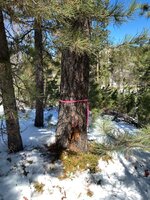
Surveyors and National Forest specialists, I have a question. I found this tag on two trees about 15’ apart, on top of a 400’ steep table in the middle of national forest 10 miles from private land. The trees were aspens in a boulder field and in danger of falling down.

Initial search says bearing trees are used for surveying, establishing property lines and demarcating private/public.

Why would they be no where near private land in a very difficult to access area?

IMG_6276.jpeg
 
Surveyors and National Forest specialists, I have a question. I found this tag on two trees about 15’ apart, on top of a 400’ steep table in the middle of national forest 10 miles from private land. The trees were aspens in a boulder field and in danger of falling down.

Initial search says bearing trees are used for surveying, establishing property lines and demarcating private/public.

Why would they be no where near private land in a very difficult to access area?

View attachment 942050
These and monument markers were used when the national forests were surveyed and mapped. Most have forgotten that paper maps existed long before OnX.
 
When the area is surveyed a marker is driven or somehow attached to the earth at certain point of reference. The marker is anywhere from 3/4 iron pipe to 2" aluminum with a cap that's inscribed with data. It would be very difficult to find without a lot of survey work so that's the bearing tree's job. On the tag it gives distance and direction to the marker.
 
Yep, it can be kind of fun locating the section corners that have been surveyed many years ago. I find bearing trees a lot, locate the 2-3 trees and read the markers and it will tell you which way and how far to the section/1/4 section marker. Can usually tell which corners have actually been surveyed by scrutinizing the 7.5" quads.
 
Ive heard of trees marked similar to this as "witness" trees. Illegal to cut down as they are used to locate property markers.
 
The plastic tag is just a generic tag indicating it is a bearing tree, the tags with the direction and distance are usually metal with places for the numbers to be scratched into the metal.
 
Such a cool part of history in Surveying. To add, there used to be a large "Check list" or listing that a surveyor had to fill out when selecting the tree itself based on tree type, how long they would last (Aspens would be a poor choice) etc.

In short, a "Bearing tree, or Witness Tree" were used to orient surveyors to a location/mark on the ground. You could find the trees, and calculate the bearing and distance to the actual mark (corner) on the ground.
 
It’s a reference to a corner. The plaque you posted should normally include a township, range, section, bearing(direction) and a distance to referenced monument. Monuments can be a variety of things iron pipes or pins, to pipes with aluminum caps on them, to stones. The tree you posted should have a scar on it with a bearing carved into it. It’s likely been grown over.

This bearing tree was 8” in diameter in the mid 1890’s and when we recovered it 120ish years later it was 32” in diameter and healthy as can be. The scar is under the little notch at base of tree.
IMG_6987.jpeg
 
Not that I noticed, but could have been.
There’s a corner close by. Sometimes there will be a bunch of flagging and sometimes the stake will be covered up. 20 years ago there weren’t phones with GPS. bearing trees make it a whole lot easier to find a corner stake that’s sticking up a couple inches in the middle of the woods.
 
Thanks for all the input. I figured it was for some sort of location reference but didn’t realize corners would still be marked in national forest. They were in quite a hell hole.
 
Thanks for all the input. I figured it was for some sort of location reference but didn’t realize corners would still be marked in national forest. They were in quite a hell hole.
I believe that almost every single section corner was marked, regardless of land ownership, in the original surveys laying out the West.

My dad was a land surveyor for Idaho Dept of Lands and as a teen I went on a few work trips with him in the summers to drive a 4wheeler around and set up reflectors for him. Most of the surveys I helped with were relocating the original corners to establish a current survey in preparation for a timber sale or land trade. He would print out scans of the original surveys notes and it was a bit like a scavenger hunt trying to go find whatever rock, tree, or stump they used to designate the section corners in the late 1800's.
 
that is why bearing tree signs are also there. If not, markers may be hard to see by skidder operators, and can get destroyed. I’ve seen as many as 3 signs offsetting the same corner
That's for redundancy, and the ability to calculate the position of the actual section corner using angles and distances from the trees back to the cap.
 
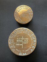
I’ve been on construction sites where monuments had to be removed/relocated due to excavation, fill, etc. . I’ve also seen some state geological agencies’ monuments are non-brass material.
IMG_0027.jpeg
 
Back
Top