dblust
FNG
Universal Transverse Mercator (UTM) has, for well over half a century, proven itself the standout map grid system for back country navigation. It’s simple, easy to use, and provides for wonderfully precise position plotting with United States Geological Survey (USGS) topographic maps.
Whether you are using full-size “store-bought” topos or the reduced-to-letter-size versions generated with mapping software like Terrain Navigator Pro, what is needed to plot positions or determine grid coordinates is a simple little device called a “Corner Scale,” “Romer Scale,” or “Roamer Scale.”
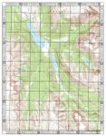
(The map must, of course, be UTM-gridded. Some “store-bought” topos, particularly those that cover national parks and adjacent regions, come gridded off the shelf. Those that do not can be gridded by hand. If software such as Terrain Navigator Pro is being used to generate maps, the program can be set to provide the grid. In addition, Terrain Navigator Pro’s UTM grid includes 100-meter hashmarks along the map’s edges for the 1:24,000 base maps, and 1,000-meter hashmarks for smaller scales, which facilitates plotting without a corner scale, though with some loss of precision. Below is a 1:50,000 topo generated by TR Pro, complete with UTM grid and hashmarks, plus a close-up of the map’s northwest corner that better illustrates the grid.)


The corner scale is used the determine the UTM grid coordinate within the grid square on the map, and must match the map’s scale, which, for USGS maps, means a scale of 1:24,000, 1:25,000, 1:50,000, 1:100,000, or 1:250,000.
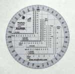
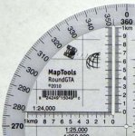
Dozens of corner scale designs have been produced over the years, but the best one I’ve ever encountered is the “Round Military Style UTM/MGRS Tool” manufactured by MapTools at http://maptools.com/ , shown below. (Also included is a closeup.)


The RMS Tool, as I call it for short, is made of clear plastic. It’s 4.75" wide, about the size of a CD, and offers a number of features. First, it carries corner scales for all the USGS topographic maps - 1:24,000, 1:25,000, 1:50,000, 1:100,000, and 1:250,000 - and facilitates position plotting down to 10 meters with 1:24,000 or 1:25,000 maps. In addition, the scales are slotted on one side, which makes good, precision plotting faster, handier, and more foolproof.
The RMS Tool also features a large-print degree scale around the edge in black numbers backed with white, which makes for easy, precise reading and enables working with compass bearings down to half a degree.
This particular tool can be seen on the MapTools website at http://maptools.com/products/RoundGTA.html . It’s $8.00 plus postage, and I highly recommend it.
MapTools has an excellent selection of map devices of all kinds; for a genuine map junkie, it’s one-stop shopping. The site also features a number of first-rate tutorials that are well worth checking out.
Whether you are using full-size “store-bought” topos or the reduced-to-letter-size versions generated with mapping software like Terrain Navigator Pro, what is needed to plot positions or determine grid coordinates is a simple little device called a “Corner Scale,” “Romer Scale,” or “Roamer Scale.”
(The map must, of course, be UTM-gridded. Some “store-bought” topos, particularly those that cover national parks and adjacent regions, come gridded off the shelf. Those that do not can be gridded by hand. If software such as Terrain Navigator Pro is being used to generate maps, the program can be set to provide the grid. In addition, Terrain Navigator Pro’s UTM grid includes 100-meter hashmarks along the map’s edges for the 1:24,000 base maps, and 1,000-meter hashmarks for smaller scales, which facilitates plotting without a corner scale, though with some loss of precision. Below is a 1:50,000 topo generated by TR Pro, complete with UTM grid and hashmarks, plus a close-up of the map’s northwest corner that better illustrates the grid.)


The corner scale is used the determine the UTM grid coordinate within the grid square on the map, and must match the map’s scale, which, for USGS maps, means a scale of 1:24,000, 1:25,000, 1:50,000, 1:100,000, or 1:250,000.
Dozens of corner scale designs have been produced over the years, but the best one I’ve ever encountered is the “Round Military Style UTM/MGRS Tool” manufactured by MapTools at http://maptools.com/ , shown below. (Also included is a closeup.)


The RMS Tool, as I call it for short, is made of clear plastic. It’s 4.75" wide, about the size of a CD, and offers a number of features. First, it carries corner scales for all the USGS topographic maps - 1:24,000, 1:25,000, 1:50,000, 1:100,000, and 1:250,000 - and facilitates position plotting down to 10 meters with 1:24,000 or 1:25,000 maps. In addition, the scales are slotted on one side, which makes good, precision plotting faster, handier, and more foolproof.
The RMS Tool also features a large-print degree scale around the edge in black numbers backed with white, which makes for easy, precise reading and enables working with compass bearings down to half a degree.
This particular tool can be seen on the MapTools website at http://maptools.com/products/RoundGTA.html . It’s $8.00 plus postage, and I highly recommend it.
MapTools has an excellent selection of map devices of all kinds; for a genuine map junkie, it’s one-stop shopping. The site also features a number of first-rate tutorials that are well worth checking out.
