Why are stand alone GPS so awful?

Joined
Oct 6, 2020
Location
El Dorado County, CA
I’ve been using OnXHunt for years and recently started using CalTopo (which I don’t really like) but decided I’d make the jump into a full fledged GPS so I don’t have to keep downloading a ton of maps to my phone. I did a lot of research and bought the new “top of the line” $500 Garmin 66sr.

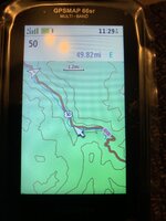
I feel like I’m back 15 years using this thing, I hate it :ROFLMAO: Seriously, how is this acceptable for something released September 2020. Here are a few screenshots of ski cabin near Tahoe. At 1.2mi scale, you can’t see much and it just looks like a vast forest. No roads (besides the highway), no trails, looks kinda flat given how spread out the topo lines are.
CA36BCE2-C1E3-465D-881A-81336269F4E9.jpeg
OK, let’s zoom 3 additional clicks and see what shows up. 0.3mi scale, huh, still nothing here and still doesn’t look particularly steep.
4AD90B61-A131-41FC-A427-D6BB5E0A5DFF.jpeg
Enhance another click to 0.2mi scale. Wow, there’s roads and trails! And lots of contour lines because it’s steep as hell there!

CD6CCFDE-2182-4155-BD90-C64B75D6C69E.jpeg
Contrast with OnX in the same area and with the same FOV as the GPS 1.2mi scale you can clearly see that there are trails and roads. You can easily tell it’s steep. No need to zoom all the way in to know that another trail is just over the next ridge or endless scrolling to see where some water might be.

F8F093EE-E4BE-42A6-9E80-1600927F7326.png

I would rather buy a separate iphone and fill the whole thing up with saved maps than use this hunk of junk. What am I missing here?
 

Attachments

  • 56445412-EEE3-4E14-AF1B-6D0A92635930.jpeg
    56445412-EEE3-4E14-AF1B-6D0A92635930.jpeg
    240.9 KB · Views: 51
I haven't brought a dedicated GPS into the woods since 2014. Primary for me is my phone, just get a waterproof case for it and make sure it has a fresh battery.

Backup is a Garmin Fenix on my wrist, and an Inreach.

I *might* consider replacing my inreach with a MOntana 700 Series as it looks like that's about as good as Garmin gets, but expensive.

 
I agree that the Garmin GPS's feel like a throwback to the 2000's, but still a better alternative than bringing a smartphone into the woods IMO.
I think you are going to have to expound on this as I would venture there is an overwhelming majority who disagree.

What am I missing with the dedicated gps unit.

FWIW I still have one, that never gets used. as the op posted, it’s laughable compared to all the available apps and software u can get on a smartphone
 
I ditched my gps for all the same reasons. Nothing is intuitive and it really feels like once touchscreen cell phones came out the gps game stopped improving all together.
 
To answer the question of why, i'm guessing there just isn't enough market for them to spend the money on better tech. Phones are so awesome because the demand for them is enormous and there is a lot of money to be made. They also cost a thousand bucks so they should be pretty great.

But yea Onx on a phone for the win.
 
I think you are going to have to expound on this as I would venture there is an overwhelming majority who disagree.

What am I missing with the dedicated gps unit.

FWIW I still have one, that never gets used. as the op posted, it’s laughable compared to all the available apps and software u can get on a smartphone
Yes I'm aware I'm in the minority, but I'm sure there's others like me that don't want such an annoying device to ruin my experience when I'm outdoors. I'll gladly take the GPS unit that only gives me the navigation I need to know and nothing else.
 
Yes I'm aware I'm in the minority, but I'm sure there's others like me that don't want such an annoying device to ruin my experience when I'm outdoors. I'll gladly take the GPS unit that only gives me the navigation I need to know and nothing else.

I 1000% agree. When it comes to mountain time, I can’t get far enough away from a phone. I’ve ditched the smartphone in my regular life too.
 
😂. That’s fine and I can understand that aspect. Other than the downloading maps I thought I may be missing something.

Also. Airplane mode.
 
I 1000% agree. When it comes to mountain time, I can’t get far enough away from a phone. I’ve ditched the smartphone in my regular life too.
All for ditching the smartphone (as I type on one) but in the woods it’s indispensable for mapping. BP hunting I only run into coverage about 15-20% of the time in my areas and I only know that from short scouting missions. When on the hunt I always leave my phone in airplane mode with all apps off except Gaia. I do this for battery savings but it has the double benefit of turning my smartphone into a “handheld gps” for the hunt.

This will be the first year I stop packing my garmin as a backup, bringing an older phone instead (which still has 3 times the storage that the garmin does, in a package 1/2 the size and weight).
All of this. Plus my phone is a camera for documenting the hunt, an mp3 player and an ebook reader when I get bored, a back up flashlight, a ballistic calculator.... probably more. That's a lot of weight savings in devices.
 
Most of the preloaded standard maps on a GPS are 100k and pretty much useless for anything hunting related in the field. Load it up with maps at 24k using a chip or download the maps to the gps and the detail will improve quite a bit to where it is functional/useful in the backcountry. Without the 24k map level detail it’s kind of useless for my needs.
 
I use my old Garmin 60csx with OnX and it does everything I need it to do or want it to do. I generally don't use a GPS all that much while actively hunting. I use it after my hunt is over to more quickly find my way back to where I hung the meat bags......or for a straight line track back to the truck or camp. Maybe mark a few interesting waypoints here and there. I hunted for years without a GPS without too many issues, so having mapping software isn't going to be something magical that's going to change my hunts at all. I have maps in my pack as well.

Whether it's a GPS or a smart phone with maps, they're both just tools for whatever job you want them to do. Pick whatever tool is best for that. For me, the smart phone is just a heavy paper weight.
 
Last edited:
You're missing the part where you research the handheld gps resolution specs and included mapping.
If you know of a stand-alone GPS with a higher resolution screen and better included mapping please let me know. As far as I could tell this is the best it gets while still having physical buttons.
@Hunt_Jefferson I'm pretty sure you can increase the detail seen at different zooms in the settings.
I have it set for highest detail
Most of the preloaded standard maps on a GPS are 100k and pretty much useless for anything hunting related in the field. Load it up with maps at 24k using a chip or download the maps to the gps and the detail will improve quite a bit to where it is functional/useful in the backcountry. Without the 24k map level detail it’s kind of useless for my needs.
is this what you are talking about? another $100 to make a $500 device worthwhile? https://buy.garmin.com/en-US/US/p/27610

I will give the 66sr one benefit over a smartphone in airplane mode with saved maps, you can use it with gloves and in the rain because of the physical buttons. Using a touchscreen device in the rain is not fun.
 
If you know of a stand-alone GPS with a higher resolution screen and better included mapping please let me know. As far as I could tell this is the best it gets while still having physical buttons.

I have it set for highest detail

is this what you are talking about? another $100 to make a $500 device worthwhile? https://buy.garmin.com/en-US/US/p/27610

I will give the 66sr one benefit over a smartphone in airplane mode with saved maps, you can use it with gloves and in the rain because of the physical buttons. Using a touchscreen device in the rain is not fun.
My Garmin allows you to download imagery, and I am pretty sure it is an older model of the one you have. The thing that sucked is that it was Garmin's imagery, and you had to have a subscription for it. I chose to never use it.
 
If you know of a stand-alone GPS with a higher resolution screen and better included mapping please let me know. As far as I could tell this is the best it gets while still having physical buttons.

I have it set for highest detail

is this what you are talking about? another $100 to make a $500 device worthwhile? https://buy.garmin.com/en-US/US/p/27610

I will give the 66sr one benefit over a smartphone in airplane mode with saved maps, you can use it with gloves and in the rain because of the physical buttons. Using a touchscreen device in the rain is not fun.
Yes. They have it available in a download or a SD card format. There are pros and cons to each method. (I'm not affiliated with Garmin. Just trying to help you out; some of the aspects of using a GPS are pretty lousy, as many have noted in this thread. And, yes, in buying this chip or downloading the data, you are into it for another $100.)
 
Back
Top