You are using an out of date browser. It may not display this or other websites correctly.
You should upgrade or use an alternative browser.
You should upgrade or use an alternative browser.
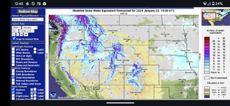
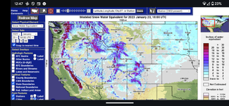
Snowpack not looking very good :(
- Thread starter mtwarden
- Start date
LeftyWilbury
WKR
yep. better plan some backpacking trips early before smokey the bear lights up a fat one.
nothin like sharing the trail with ticks and skeeters on a warm may morning.
nothin like sharing the trail with ticks and skeeters on a warm may morning.
CorbLand
WKR
- Joined
- Mar 16, 2016
- Messages
- 7,739
My area is looking decent. Winter has held off but showed up a last week and put down over a foot in 3-4 days. It has rained for the last couple and melted a lot of the snow off.
Hopefully we get some more snow in the coming weeks or very wet spring. If we can get a spring like we had in 2023, we would be in good shape.
There is still a lot of winter left for some of those areas. Back when I sledded, we use to always say it didnt get good until mid January through end of February.
- Thread Starter
- #4
The Forest Service did a pretty in-depth study some years back looking into better forecasting fire seasons. Previous to this study the number one predictor they used was snowpack, now the number one predictor is June precipitation. Obviously snowpack still plays a major role, as does Spring precip, but a very wet June can make up for at least some of that lost ground.
Amazingly our snowpack was even worse off before our near record cold snap, probably a good 10-20% lower than what it is now. My guess is that snow was probably lacking a little in the moisture department.
Amazingly our snowpack was even worse off before our near record cold snap, probably a good 10-20% lower than what it is now. My guess is that snow was probably lacking a little in the moisture department.
willfrye027
WKR
- Joined
- Dec 4, 2018
- Messages
- 2,501
Isn’t that map showing the percent normal, for this time of year? IE you could still catch up pretty quick with some good late stormsThe Forest Service did a pretty in-depth study some years back looking into better forecasting fire seasons. Previous to this study the number one predictor they used was snowpack, now the number one predictor is June precipitation. Obviously snowpack still plays a major role, as does Spring precip, but a very wet June can make up for at least some of that lost ground.
Amazingly our snowpack was even worse off before our near record cold snap, probably a good 10-20% lower than what it is now. My guess is that snow was probably lacking a little in the moisture department.
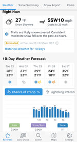
got our own in-house hydrologist @Josh Boyd scheduled on the Rokcast to air 1/29. We be talking all this.There are a few bright spots, but a lot of the West not looking good we may be in the worst shape. Our 10 day forecast shows little to no additional precip- not good.

Ucsdryder
WKR
- Joined
- Jan 24, 2015
- Messages
- 6,602
Too much snow…all the animals die
Not enough snow…all the animals die
Regardless, all the animals will be dead, hopefully everyone takes up golf.

Not enough snow…all the animals die
Regardless, all the animals will be dead, hopefully everyone takes up golf.
BBob
WKR
- Thread Starter
- #9
Isn’t that map showing the percent normal, for this time of year? IE you could still catch up pretty quick with some good late storms
Yup a good February, or even better a good February and a good March could put us back into looking good. I think the El Niño thing they predicted is real, hope it backs off a bit.
got our own in-house hydrologist @Josh Boyd scheduled on the Rokcast to air 1/29. We be talking all this.
Coolio!
Pony Soldier
WKR
Most our wet storms are march and april. As my old neighbor used to tell me - snowpack is for pilgrams and the lakes. We depend heavily on the may - june rains after the frost goes out so it can soak in. It rained heavily last summer and fall at our elevation so the aquifers aren't as bad as they could be. I would be reluctant in planning an August vacation in the timber.
- Thread Starter
- #11
Those maps are based on the median SWE (snow water equivalent) of the snowpack compared to the 1991-2020 median values. You can click on each individual site to see how it compares in graphical form with previous years. There is a TON of cool data stored within the Snotel databasesIsn’t that map showing the percent normal, for this time of year? IE you could still catch up pretty quick with some good late storms
To answer your question, yes, we can catch up. In MT I believe late February-April are our big SWE storing months.
willfrye027
WKR
- Joined
- Dec 4, 2018
- Messages
- 2,501
I follow a few different versions. Just not sure what provides the most relevant info for keeping tabs on the overall conditions for mule deer. Locally we are “out of the drought” but I can tell you we had late fall precipitation and late green up which is not great for my local deer herd. Obviously the snotel data was pretty spot on predicting last years winter kill. All interesting stuff.Those maps are based on the median SWE (snow water equivalent) of the snowpack compared to the 1991-2020 median values. You can click on each individual site to see how it compares in graphical form with previous years. There is a TON of cool data stored within the Snotel databases
To answer your question, yes, we can catch up. In MT I believe late February-April are our big SWE storing months.
I mean, "conditions for mule deer" is incredibly complicated and far exceeds 1-yr of precip data. You'd need to know vegetative conditions and structure, browse quality, browse patterns over time, historical logging, fire, etc etc.I follow a few different versions. Just not sure what provides the most relevant info for keeping tabs on the overall conditions for mule deer. Locally we are “out of the drought” but I can tell you we had late fall precipitation and late green up which is not great for my local deer herd. Obviously the snotel data was pretty spot on predicting last years winter kill. All interesting stuff.
I would also argue that Snotel is not a great predictor of winter-kill due to the station placements. Snotel's purpose is to track water storage for use (irrigation, predicting reservoir storages, river flows for transport and irrigation use, etc), so the stations are built at high elevations where the vast amount of storage occurs. Mule deer (in general) are not wintering at high elevations. They are much more affected by low elevation snowfall and Snotel does not have a ton of low elevation stations, although I believe they are going to be building some.
The most useful metric to track in Snotel would prob be water year precip % of median and soil moisture. I track a number of other databases when looking for productive mule deer habitat, but I am not sharing those with anyone.
CorbLand
WKR
- Joined
- Mar 16, 2016
- Messages
- 7,739
Keep in mind that this is SWE so 10 inches of heavy wet snow can have a higher SWE than 100 inches of light snow.I'm surprised it's as high as it is in SW Montana, thought it would be way lower. Lot's of season to go but it's been a light precip year for sure.
LongWayAround
WKR
- Joined
- Aug 10, 2015
- Messages
- 2,681
Hopefully it will improve in November.Add it to the list of things that take a turn for the worst in 2024.
I wonder when we'll finally hear some good news?
LongWayAround
WKR
- Joined
- Aug 10, 2015
- Messages
- 2,681
LongWayAround
WKR
- Joined
- Aug 10, 2015
- Messages
- 2,681
Similar threads
- Replies
- 21
- Views
- 2K
Featured Video
Stats
Latest Articles
-
WE WON!
-
Mule Deer Rut Update & Buck Story
-
Sitka Gear HyperDown Sleeping Bag Review
-
TT#42 Mark Denham with Outdoorsmans history and innovations.
-
Kryptek Traverse Merino Review
-
First Lite 308 Pant Review
-
Argali Selway 6P Tent Review
-
AGC Kobuk 2800 Backpack Review
-
Hunting The Leaf-off Window
-
TT#41 Jordan Budd’s Tips on Finding and Killing the Big One


