New land where to start?

Joined
May 22, 2023
Messages
334
Lets say I found a 200 acre parcel I’ve never hunted before. Where would you start tackling how to hunt it?

It’s a mix of mature hardwoods(oaks and maple), swamps and aspen regeneration.

Edited: November Rifle season and December Muzzleloader season in Central to Northeastern Minnesota.
 
Last edited:

Macintosh

WKR
Joined
Feb 17, 2018
Messages
2,753
Lets say I found a 200yard parcel I’ve never hunted before. Where would you start tackling how to hunt it?

I’ve got thousands of acres north of my house of public land and really have a hard time deciding where to start scouting in the field. It’s a mix of mature hardwoods(oaks and maple), swamps and aspen regeneration.
200 yard? Typo? Are you talking about where to start scouting a big thousands-acre parcel you’ve never been to?
What part of the country, and what time of year you hunting it?
 
OP
Ringbill27
Joined
May 22, 2023
Messages
334
200 yard? Typo? Are you talking about where to start scouting a big thousands-acre parcel you’ve never been to?
What part of the country, and what time of year you hunting it?
Ope… fixed. November-December northeastern Minnesota with minimal AG in the area.
 

Macintosh

WKR
Joined
Feb 17, 2018
Messages
2,753
Is the 200 acre parcel part of the thousands, or is that different? If different are they close to each other? I'm not clear if it is an example parcel for how you'd approach hunting any public parcel, or if it is a distinct question separate from the thousands of acres north of your house. Is the 200 acre parcel public, and how much pressure does it get? And how close to the other public? I might approach very differently depending on your answer.

In that kind of area 200 acres is not necessarily a big parcel depending on what it is...bowhunting 200 acre of mixed hardwood knobs and small swamps and marshes might be a cool area to spend a lot of time, wheras gun hunting a 200 acre mountain thats all open hardwoods and doesnt have much terrain on it could be pretty limiting and I'd for sure want to augment it with other areas I'd scouted.

Around me, any white oak like a burr oak drops acorns very early in the season, and those are completely out of play well before november. Red oak acrons will be all that's left by the time november rolls around, and those are generally more of a preferred food source late int he season (or even next spring) depending on snow cover.
 
OP
Ringbill27
Joined
May 22, 2023
Messages
334
Is the 200 acre parcel part of the thousands, or is that different? If different are they close to each other? I'm not clear if it is an example parcel for how you'd approach hunting any public parcel, or if it is a distinct question separate from the thousands of acres north of your house. Is the 200 acre parcel public, and how much pressure does it get? And how close to the other public? I might approach very differently depending on your answer.

In that kind of area 200 acres is not necessarily a big parcel depending on what it is...bowhunting 200 acre of mixed hardwood knobs and small swamps and marshes might be a cool area to spend a lot of time, wheras gun hunting a 200 acre mountain thats all open hardwoods and doesnt have much terrain on it could be pretty limiting and I'd for sure want to augment it with other areas I'd scouted.

Around me, any white oak like a burr oak drops acorns very early in the season, and those are completely out of play well before november. Red oak acrons will be all that's left by the time november rolls around, and those are generally more of a preferred food source late int he season (or even next spring) depending on snow cover.
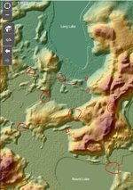
Ok the 200 acres is different than the land north of my house. Let’s focus on the 200 first. The 200 acres Is half big ridges of red oak or very young aspen regeneration. The other half is swamps or small lakes. See photos. Forest roads run most of the ridges. Due to access and the recent logging pressure has dwindled, mostly just walkers on the roads.

Removed the land north of my house for a later post. I see the confusion now.
 

Macintosh

WKR
Joined
Feb 17, 2018
Messages
2,753
gotcha. It looks like the swampy stuff is pretty wet, or is it mostly dry? Looking at the terrain map there are some very distinct terrain features that I'm guessing will show very distinct trails. I'd plan a good long walk to hit all of the major "connections" like this that form a bridge or a "shortest route" between the various areas of high ground where an animal crossing from ridge to ridge would most easily cross one of the swampy areas or cross one of the bigger ridges--I just circled a few below to show what I mean, but theres others and some of these may have roads, etc on them that you want to avoid. Maybe also check out some of the points that fade into the swamps that I didnt circle. Theres also a few places where multiple ridges converge, if those arent travelled or dont have trails on them they could be another good spot to check out.
image with circles.JPGI'd plan a walk to hit as many of these as you can and identify the most heavily used trails, as well as mark areas with good fall food sources--clearcuts with browse, swamp edges or blowdown areas with browse, areas of oaks with good acorn crop (bring binos to see acorns on the trees). I'd follow some of the heavily used trails into the swamp if posible, so if its wet bring your mud boots. guessing you'll find bedding areas in the swamps as well as on midslope benches and knobs. I'd also be looking in the swamp, on the swamp exit trails, and any of the ridges dropping into the swamps, for any concentrations of rubs, especially if they show signs of having been rubbed more than just one year. during rut some of the terrain funnels themselves and any terrain funnels near bedding benches/knobs can make a good sit based on sign, the trails and swamp edges can make a good still-hunt, and any of the funnels or feeding areas and swamp edges where trails enter are good places to check if there's snow so you can pick up a buck track--200 acres isnt big enough to track a buck most times, but that technique will transfer to the bigger areas of public nearby. I bet if you do a power scouting day like that you will identify some hot spots to go back to and hunt--maybe some of what you targeted and some other stuff that didnt jump out on the map--and that'll likely be enough to get you in the game for some hunts int he fall, and you can adjust on the fly from there. If you want that will also identify the best places to hang a camera if you want to go that route to get more info. There's always stuff that is hidden and isnt on a quick first look like this, so this isnt at all a end-all/be-all for what to scout, it's just how I'd approach a first scouting trip never having been there. Curious what others see as well, I feel like everyone sees different things on a map like this so i enjoy hearing what jumps out to other folks.
 

WCB

WKR
Joined
Jun 12, 2019
Messages
3,638
OP, the piece you are looking at is over 400 acres (took me 5minutes to find it). In terrain like that I would get the hip waders on and try to get to secluded islands or tight pinch points connecting larger segments of woods. MZ season if there is snow you should be able to get on sign fairly easy. Deer will be bedded in the thick jungles or along the edges of the sloughs. Hard part is that is some crappy bog country and anything actually open water is probably too deep to cross. Also, horrible deer hunting in general in that area. I can't imagine it doesn't get hit fairly hard.

This year is WET and it may be even harder to get to some of those place even if it freezes some of that type of country doesn't freeze real hard till LATE.

IMO unless you for some reason are married to that area...I would find somewhere else to hunt.
 

5811

WKR
Joined
Jan 25, 2023
Messages
591
From a 30k ft view, I'd be tempted start on the east side of long lake, towards the private land with the field. The county gis website has very detailed wetland maps and recent aerials. I'd be looking for trails from the field to water to high ground.
 
OP
Ringbill27
Joined
May 22, 2023
Messages
334
gotcha. It looks like the swampy stuff is pretty wet, or is it mostly dry? Looking at the terrain map there are some very distinct terrain features that I'm guessing will show very distinct trails. I'd plan a good long walk to hit all of the major "connections" like this that form a bridge or a "shortest route" between the various areas of high ground where an animal crossing from ridge to ridge would most easily cross one of the swampy areas or cross one of the bigger ridges--I just circled a few below to show what I mean, but theres others and some of these may have roads, etc on them that you want to avoid. Maybe also check out some of the points that fade into the swamps that I didnt circle. Theres also a few places where multiple ridges converge, if those arent travelled or dont have trails on them they could be another good spot to check out.
View attachment 756052I'd plan a walk to hit as many of these as you can and identify the most heavily used trails, as well as mark areas with good fall food sources--clearcuts with browse, swamp edges or blowdown areas with browse, areas of oaks with good acorn crop (bring binos to see acorns on the trees). I'd follow some of the heavily used trails into the swamp if posible, so if its wet bring your mud boots. guessing you'll find bedding areas in the swamps as well as on midslope benches and knobs. I'd also be looking in the swamp, on the swamp exit trails, and any of the ridges dropping into the swamps, for any concentrations of rubs, especially if they show signs of having been rubbed more than just one year. during rut some of the terrain funnels themselves and any terrain funnels near bedding benches/knobs can make a good sit based on sign, the trails and swamp edges can make a good still-hunt, and any of the funnels or feeding areas and swamp edges where trails enter are good places to check if there's snow so you can pick up a buck track--200 acres isnt big enough to track a buck most times, but that technique will transfer to the bigger areas of public nearby. I bet if you do a power scouting day like that you will identify some hot spots to go back to and hunt--maybe some of what you targeted and some other stuff that didnt jump out on the map--and that'll likely be enough to get you in the game for some hunts int he fall, and you can adjust on the fly from there. If you want that will also identify the best places to hang a camera if you want to go that route to get more info. There's always stuff that is hidden and isnt on a quick first look like this, so this isnt at all a end-all/be-all for what to scout, it's just how I'd approach a first scouting trip never having been there. Curious what others see as well, I feel like everyone sees different things on a map like this so i enjoy hearing what jumps out to other folks.
Holy smokes that’s a lot of info. Thank you. I’ll go for a stomp.
OP, the piece you are looking at is over 400 acres (took me 5minutes to find it). In terrain like that I would get the hip waders on and try to get to secluded islands or tight pinch points connecting larger segments of woods. MZ season if there is snow you should be able to get on sign fairly easy. Deer will be bedded in the thick jungles or along the edges of the sloughs. Hard part is that is some crappy bog country and anything actually open water is probably too deep to cross. Also, horrible deer hunting in general in that area. I can't imagine it doesn't get hit fairly hard.

This year is WET and it may be even harder to get to some of those place even if it freezes some of that type of country doesn't freeze real hard till LATE.

IMO unless you for some reason are married to that area...I would find somewhere else to hunt.
That’s fine you found it. Seems like a weird flex. I really used this as an example to see what to look for when looking at a chunk of land. Also I’m kinda of married to it because my wife’s family deer camp uses this property. In the last 5ish years 65% this property has been logged and beavers have a large portion of the swamps flooded. All the old spots have changed so much that they don’t work anymore.
 
Last edited:
OP
Ringbill27
Joined
May 22, 2023
Messages
334
From a 30k ft view, I'd be tempted start on the east side of long lake, towards the private land with the field. The county gis website has very detailed wetland maps and recent aerials. I'd be looking for trails from the field to water to high ground.
I’ve hunted that side and the other hunters over there have been dicks. So I tend to stay out of there.
 

Bcleck90

WKR
Joined
Jul 2, 2017
Messages
890
Location
Alabama
@WCB quit flexing 🤣

I’m just here for the dumbest lake names ever. OP I hope you figure it out but who the hell names a lake Long/ Round and just calls it a day. That’s hilarious!
 

Macintosh

WKR
Joined
Feb 17, 2018
Messages
2,753
I think its universal. Im fairly certain its written into more than one state constitution that there shall be at least 1 each mud pond, long lake, clear pond, in every county.
 

WCB

WKR
Joined
Jun 12, 2019
Messages
3,638
@WCB quit flexing 🤣

I’m just here for the dumbest lake names ever. OP I hope you figure it out but who the hell names a lake Long/ Round and just calls it a day. That’s hilarious!
Didn't know I was flexing...gotta back off on the TRT apparently. But guys post exact locations with lake names in a very very popular area and apparently I'm the weird one.
 
OP
Ringbill27
Joined
May 22, 2023
Messages
334
Didn't know I was flexing...gotta back off on the TRT apparently. But guys post exact locations with lake names in a very very popular area and apparently I'm the weird one.
Very very popular? Apparently you are familiar with this area. Not sure I would have used very let alone twice.
 
Last edited:
Top