Hi everyone,
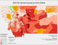
I've been teaching myself GIS for work reasons, and besides online coursework I started a project on my own using MT's publicly available harvest estimate numbers run through some ArcGIS processes to produce maps of HDs paired with an estimated success rate for a given species and year.
Here is an example of what I'm talking about:

I know there's some stuff that this map doesn't represent well (type b/antlerless, draw-only districts, etc.), this is more a proof of concept. But what do people on here think about it? Is this at all useful? I'm imagining the target user being either a new-to-hunting resident or a non-resident who doesn't have the money or desire for the catered experience of a guided hunt. Do you feel like this is blowing up the spot? I want to hear those concerns as well, though my initial thought on the issue that this isn't granular enough data to have someone walking into your honeyhole, more to point someone who's dedicated enough to put in the miles in the right direction. That and the fact that this is all public data means it's already out there, though not necessarily in a digestible format.
Is someone already doing this and I've just missed it? seems like a pretty natural extension of the"e-scouting" that OnX and the like are pushing.
If it's something you could use, what else would be useful? I'd like to include district draw odds, publish maps for all species there's reliable data for, maybe start doing other states as well. My thought is if there's enough interest to perhaps start a patreon or substack and see where it goes.
Thanks for the feedback!
I've been teaching myself GIS for work reasons, and besides online coursework I started a project on my own using MT's publicly available harvest estimate numbers run through some ArcGIS processes to produce maps of HDs paired with an estimated success rate for a given species and year.
Here is an example of what I'm talking about:

I know there's some stuff that this map doesn't represent well (type b/antlerless, draw-only districts, etc.), this is more a proof of concept. But what do people on here think about it? Is this at all useful? I'm imagining the target user being either a new-to-hunting resident or a non-resident who doesn't have the money or desire for the catered experience of a guided hunt. Do you feel like this is blowing up the spot? I want to hear those concerns as well, though my initial thought on the issue that this isn't granular enough data to have someone walking into your honeyhole, more to point someone who's dedicated enough to put in the miles in the right direction. That and the fact that this is all public data means it's already out there, though not necessarily in a digestible format.
Is someone already doing this and I've just missed it? seems like a pretty natural extension of the"e-scouting" that OnX and the like are pushing.
If it's something you could use, what else would be useful? I'd like to include district draw odds, publish maps for all species there's reliable data for, maybe start doing other states as well. My thought is if there's enough interest to perhaps start a patreon or substack and see where it goes.
Thanks for the feedback!
