Navigation
Install the app
How to install the app on iOS
Follow along with the video below to see how to install our site as a web app on your home screen.
Note: This feature may not be available in some browsers.
More options
Style variation
You are using an out of date browser. It may not display this or other websites correctly.
You should upgrade or use an alternative browser.
You should upgrade or use an alternative browser.
Do you trust OnX?
- Thread starter Colby3
- Start date
35WhelenAI
WKR
- Joined
- Nov 20, 2021
- Messages
- 2,147
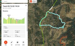
This maybe out there... Most rangefinders take into account inclination. Is there a GPS system, OnX or otherwise, that takes into account elevation and distance horizontally to be fairly close with respect to distance traveled? My thought is with a barometric altimeter or gps elevation along with distance based on map scale it would be pretty much spot on.
Last edited:
- Banned
- #63
Indian Summer
WKR
- Joined
- Feb 17, 2013
- Messages
- 2,670
If you are planning routes mileage is only half the equation. Mileage plus elevation gain is a whole other ballgame. Sometimes 6 miles is far. Sometimes it isn’t. Sometimes it takes more time and effort to go 3.
35WhelenAI
WKR
- Joined
- Nov 20, 2021
- Messages
- 2,147
Regardless of Onyx or gps, etc are those using elevation in their calculation or is it straight flat map surface mileage?
wapitibob
WKR
35WhelenAI
WKR
- Joined
- Nov 20, 2021
- Messages
- 2,147
Thank you!
Johnpaulameen365
FNG
- Joined
- Jan 17, 2022
- Messages
- 11
I’ve always thought that OnX overestimated Distance traveled, I guess I will have to take a better look at it.
Similar threads
Featured Video
Latest Articles
- TT#64 Josh Boyd Elk Hunting Strategies for Every Season
- Aaron Davidson of Gunwerks
- TT#63 Dirk Durham’s Art of Elk Calling
- BIG Buck Stories with the Dirty Giants Podcast
- TT#62 Brian Barney Hunting Bulls without Calling
- Hoyt Alpha AX-2 SD Review
- Kuiu Kenai vs Outdoor Vitals Vario Hooded Jacket Review
- Hoyt RX-9 Ultra Review
- Hunting Vampire Bucks & Building an Optics Kit
- Darton Sequel ST2 35 Review

