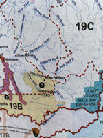
This is the actual falsified map that was used at trial to convict David Haeg. (With one exception blue line which was added to show the actual true boundary as shown in the hunt reg book).
Notice how they falsely drew the pink line with a very definitive protrusion far to the west to include the black boxes, highlighted in pink, which were the wolf kill sites.
Again, the blue-green line was NOT on the map when shown to the jury. The pink-orange line WAS on the map when shown to the jury and I don’t know how anyone can argue that such an obvious protrusion that simply encompassed the wolf kill sites as the prosecutor falsely drew, can be legitimately considered a simple mistake.
No, it was blatant and a felony to knowingly present false testimony to convict someone. Prosecution KNEW because there is tape recorded discussion of the shooter, the Trooper, and the prosecutor discussing the FALSIFIED map PRIOR to the trial.
Two more quick notes.... testimony was given in court later that affirms what I just wrote and is in documented court transcripts.
Also, this map that was falsified and used in court by the State was not given to Haeg’s Attorney under discovery prior to trial as REQUIRED by law.
What I just laid out is all verifiable and only the tip of the iceberg of what corruption is going on.... and PROVABLE.
It could be you in his position. It could be anyone. He needs support and we need to make this court corruption common knowledge with the public.
please comment on info I presented.