Calculating backcountry miles

Snowhunter11

Lil-Rokslider
Joined
Sep 16, 2022
Messages
170
Location
North Dakota
Calculating backcountry miles..

Is their a percentage you guys add on when route planning over crow flies? I recently went on a sheep hunt about 10 miles deep for 7 days. "wrist watch miles" around 55. Obviously in that ten miles we shifted to glass, get water, etc. I have calculated a new albeit much longer route for next year and added 20%. An impossible variable I know.. Anyways just trying to see what other use when established trails are non existent. On multiday back pack hunts its nice to rough plot sleeping areas" or flat spots" , glassing points, and set goals to achieve. I appreciate any educated feedback.
 
Last edited:

def90

WKR
Joined
Aug 12, 2020
Messages
1,714
Location
Colorado
I don’t think I’ve ever sat there and calculated miles, I just decide where I want to go, formulate some sort of plan and then get there and find out the wind is wrong and end up doing something different.

Pretty sure that OnX calculates on the ground miles if you use their tool to lay out a route.
 
OP
Snowhunter11

Snowhunter11

Lil-Rokslider
Joined
Sep 16, 2022
Messages
170
Location
North Dakota
Right I am adding to the on x numbers because the numbers are off when you are constantly zig zagging, climbing through blow down, and going around boulder fields the size of volvos! You can only see so much on google earth or onx imo..
 

S.Clancy

WKR
Joined
Jan 28, 2015
Messages
2,532
Location
Montana
If you track the route while hiking with a GPS that should be reasonably close. You could then compare those tracks with routes drawn in OnX or Google Earth and determine your own adjustment factor
 
OP
Snowhunter11

Snowhunter11

Lil-Rokslider
Joined
Sep 16, 2022
Messages
170
Location
North Dakota
True.. Every terrain type may have a different rough variable. Only gps I carry due to weight restrictions is a garmin inreach mini 2. Due to limited battery time I only have tracking on every 30 mins or off.
 
Last edited:

MTtrout

WKR
Joined
Jan 2, 2013
Messages
382
Without using a gps tracking device you will never know. If you’re interested in knowing and concerned about weight why not try a gps watch or use your phone with a light weight battery cell?

As far as looking at Google Earth or other imagery, learn how to understand topology and terrain signatures to have a better grasp on what the “crow flys” really means
 

Koda_

WKR
Joined
Dec 24, 2023
Messages
318
Location
PNW
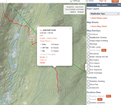
caltopo.com has a route tool that estimates off trail travel time. One of the better phone GPS apps out there.
1706854272807.png
 

ozyclint

WKR
Joined
Apr 27, 2012
Messages
1,959
Location
Queensland, Downunder
When in the west coast mountains of NZ, distances are quoted in hours and days.
You can literally glass animals from camp with 10x binos that are 2 days away. (Sometimes, as crow flies, a mile is 2 days)
 

kevlar88

Lil-Rokslider
Joined
Nov 19, 2018
Messages
229
Location
Hawaii/Texas/Germany
When in the west coast mountains of NZ, distances are quoted in hours and days.
You can literally glass animals from camp with 10x binos that are 2 days away. (Sometimes, as crow flies, a mile is 2 days)
58 more days and l’ll be experiencing that for myself, but who’s counting.
 

Wrench

WKR
Joined
Aug 23, 2018
Messages
6,363
Location
WA
Im also a time guy. Some guys may hike at faster paces, but for the most part, we all creep along at a similar pace when hunting.
 

jonesn3

Lil-Rokslider
Joined
Jan 11, 2022
Messages
256
A pretty accurate way is using Naismith Rule. Check out Wikipedia, there’s a good write up there. Basically, its a quick calculation that accounts for flat hiking pace and elevation gain. Off the top of my head is like 1-2 mph flat pace and an addition 30-45 mins pers 1000 ft of elevation gain. You can factor in whether it’s on-trail or off-trail routes. Keeping track of your tracks and hiking speed in the field helps calibrate the calc based your personal pace. It works pretty good when I’ve pre-planned routes and estimated hiking times.
 
Last edited:

jonesn3

Lil-Rokslider
Joined
Jan 11, 2022
Messages
256
Here's the link for Naismith Rule

Also a little calculator tool that does the estimate for you (with some factors applied). It has some good writeup on considerations for on/off trail, pack weight, and pace. You could easily adapt that into your own spreadsheet or calculation for quick planning during escouting.

 
OP
Snowhunter11

Snowhunter11

Lil-Rokslider
Joined
Sep 16, 2022
Messages
170
Location
North Dakota
Here's the link for Naismith Rule

Also a little calculator tool that does the estimate for you (with some factors applied). It has some good writeup on considerations for on/off trail, pack weight, and pace. You could easily adapt that into your own spreadsheet or calculation for quick planning during escouting.

That is pretty damn sweet.. For people trying to plot campsites in areas with little flat spots or soft ground that could be extremely helpful! I will give it a try and see if my experience plays out in a similiar timeline. Thanks for the link.
 

jonesn3

Lil-Rokslider
Joined
Jan 11, 2022
Messages
256
That is pretty damn sweet.. For people trying to plot campsites in areas with little flat spots or soft ground that could be extremely helpful! I will give it a try and see if my experience plays out in a similiar timeline. Thanks for the link.
Not a problem! There's an app for iOS that's called like "Naismith" or something. Not the greatest app, it uses metric units, but that could be useful too for in the field since OnX doesn't have that built into their route planner. I just use an "offline" version of a spreadsheet on my phone when in the field and needing to estimate new unplanned routes
 
Top