Western Slope CO. wildfires and closures

The first thing I thought when I saw Crosho fire on Monday was "campfire left smoldering".... it started right at the lake with a bunch of camp spots around. Unknown cause but I would bet money on it. No rain/thunderstorms/ lightning around for many days prior. People not local to the DRY mountain west conditions just don't realize how dry the brush and grass is, the lack of humidity and strong winds can whip up a fire in an instant. I don't have fires because I could not live with myself if I started a forest fire.... Dragging chains have started a few along I 70 in western eagle county this summer. You have to be way more careful than you think!!! Please be careful!!
 
@RancherJohn prayers for you and everyone impacted by the fires.

A couple buds and I were in the area when the lightning started Saturday and as we were crossing the BLM roads out of there the fires were already raging and fire trucks were coming on scene. The area was/is bone dry, any roads or two tracks with grass we didn’t drive for fear of fire. We ended up staying a couple nights in a campground vs camping out on the BLM due to fire concerns. We bugged out Sunday morning as it was obvious the fires were raging through the area.

Anyone planning on camping BLM for bow season may need to cold camp, check fire restrictions ahead of time. No open flames of any type with stage 2.

IMG_4483.jpeg
 
@RancherJohn prayers for you and everyone impacted by the fires.

A couple buds and I were in the area when the lightning started Saturday and as we were crossing the BLM roads out of there the fires were already raging and fire trucks were coming on scene. The area was/is bone dry, any roads or two tracks with grass we didn’t drive for fear of fire. We ended up staying a couple nights in a campground vs camping out on the BLM due to fire concerns. We bugged out Sunday morning as it was obvious the fires were raging through the area.

Anyone planning on camping BLM for bow season may need to cold camp, check fire restrictions ahead of time. No open flames of any type with stage 2.

View attachment 921390
Going to be in the area for 2nd season.. do Jetboil type stoves fall into this? Just want to make sure we plan appropriately.. not trying to make the evening news.
 
Going to be in the area for 2nd season.. do Jetboil type stoves fall into this? Just want to make sure we plan appropriately.. not trying to make the evening news.
Per Forest service a "device solely fueled by liquid or gas that can be turned on and off in an area barren and cleared of all flammable materials within three feet of the device" is allowable. BLM has similar wording in their fire restrictions. Not sure who created the above flyer but it doesn't seem to be 100% accurate.
 

Attachments

  • Screenshot_20250815-111708.png
    Screenshot_20250815-111708.png
    303.9 KB · Views: 6
  • 17552746502481393124765422321676.jpg
    17552746502481393124765422321676.jpg
    365.8 KB · Views: 6
Going to be in the area for 2nd season.. do Jetboil type stoves fall into this? Just want to make sure we plan appropriately.. not trying to make the evening news.
If still in Stage 2 fire restrictions, I would interpret no Jetboil stoves from looking at the graphics on the poster. Our small group agreed no open flames and put plan B into effect and went to a campground and used a small camp stove. The campground was just dirt so felt comfortable with a stove on a table.

If we decide to come back and camp outside of a campground we will meal prep so there is no use of open flame.
 
We just had another fire break out this afternoon between Durango and Bayfield near Vallecito. Reportedly spreading rapidly with pre evac noticed going out to several areas.

Polis declared a statewide disaster emergency with, I believe, 8 fires now burning.
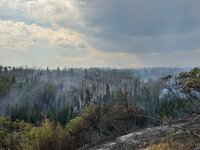

Lee Fire
New evacuations were called on Wednesday on the southern edge of the Lee Fire as it creeps closer to the city of Rifle.

The fire is only 3% contained, and that percentage dropped this week from 6% as the fire grew.

Many residents outside the town of Meeker remain evacuated.

Firefighters are working to protect structures and critical infrastructure such as oil and gas operations.

Elk Fire
The nearby Elk Fire in Rio Blanco County has been significantly controlled: It is 75 % contained at 14,518 acres.

According to daily updates from the Rocky Mountain Incident Management Team 3, firefighters and equipment are being moved to the Lee Fire burning in Rio Blanco and Garfield counties.

Both counties are big ranching communities. According to data from the U.S. Department of Agriculture, there are more than 1,000 farmers in the two counties.

On Tuesday, the president of the Colorado Cattlemen's Association, Curt Russell, told CPR News that the organization is working to provide aid to affected ranchers, including emergency funding, feed and hay, and even helping them relocate livestock to pastures on the Eastern Plains.

“After the fires are out is when the big push will come,” Russell said. “Then we'll be looking at, OK, so it burned up all your grass, it burned up all your fences. Where can we go with these cows until we can get things back together?”

He said fencing can cost tens of thousands of dollars to replace.

Crosho Fire
The Crosho Fire in Garfield, Rio Blanco and Routt Counties is 1,700 acres and 0% contained. Some evacuations have been called for the area, with other areas on standby.


Nearby residents and campers have been forced to evacuate, and several nearby county roads are closed. Nearly 200 resources are working the fire, which straddles both Rio Blanco and Routt counties.

Portions of Routt National Forest are closed

. Officials said today that the fire was growing on all sides on both public and private land.

Stoner Mesa Fire
The Stoner Mesa Fire in Montezuma and Dolores counties is 7,389 acres and 0% contained. It’s burning on public lands and no evacuations have been called, though some campgrounds have been closed.


In a daily update, Rocky Mountain Team 1 Operations Section Chief Matt Weakland said the efforts were focused on protecting the town of Rico. A fire weather watch for dry thunderstorms has been issued for Friday.

Efforts are also focused on containing the north side of the fire and preventing it from reaching Highway 38.

Oak Fire
The Oak Fire burning in Archuleta County is 78% contained at 75 acres. Evacuation orders were lifted yesterday and residents were able to return home, according to the Archuleta County Sheriff’s Office.

South Rim Fire
The South Rim Fire burning in Black Canyon of the Gunnison National Park, in Montrose County, is 4,232 acres and 52% contained.

The North Rim of the park reopened on July 31. The South Rim is set to reopen on Aug. 18. Visitors will be able to drive the South Rim Road, access the visitor and Tomichi and Gunnison Point overlooks, and visit the park store. But some portions of the park will remain closed for cleanup and repairs.

The fire is isolated in deep canyons and inaccessible areas, according to incident command. The fire is smoldering but not active, and “poses very little risk of spread outside the current fire footprint.”

Turner Gulch Fire
The Turner Gulch Fire in Unaweep Canyon outside the community of Gateway has been smoldering for over a month, with flare-ups in fire activity in recent days. Some pre-evacuations are still in place.

The fire is 29,068 acres and 53% contained, with 616 firefighters on the scene.

Crews have focused on protecting structures and preventing spread along Highway 141. Ground crews are working on controlling the western perimeter of the fire, extinguishing hot spots and digging fire lines where necessary.
 
I was up to unit 60 Tuesday and the Deer Creek fire is almost out. The forest service has 2 roads closed, but 99% of them are open. Hot and very dry
 
We have been blessed with heavy rains in July here on the front range but very hot and dry since then. Praying for you all on the western slope and the ranchers who are affected.
 
I have to give onX credit for a few things. 1, it’s nice to see where a fire is in relation to all their information. 2, I only pay for Colorado but I can see fires in other states, maybe not in great detail but for people traveling this can be helpful. 3, I don’t know what to make of it but they show satellite detected hotspots.
IMG_0907.png
 
Back
Top