GunsAreFun
WKR
- Joined
- Apr 18, 2019
- Messages
- 1,980
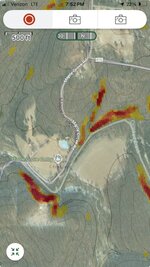
Has anyone been able to get it to work on an iPhone? I use it when escouting, especially when planning routes. It is an awesome layer that shows things the contour lines don’t and having it on the phone would be great for planning routes in the field.
For example, we ran into probably a 60-70° hill (is it a cliff at that point?) that was at least 50’ tall in CO last September that was very much missing from USGS Topo. We couldn’t find a way around and changed plans. Looking today, it was very evident with slope shading.
For example, we ran into probably a 60-70° hill (is it a cliff at that point?) that was at least 50’ tall in CO last September that was very much missing from USGS Topo. We couldn’t find a way around and changed plans. Looking today, it was very evident with slope shading.

