Navigation
Install the app
How to install the app on iOS
Follow along with the video below to see how to install our site as a web app on your home screen.
Note: This feature may not be available in some browsers.
More options
Style variation
You are using an out of date browser. It may not display this or other websites correctly.
You should upgrade or use an alternative browser.
You should upgrade or use an alternative browser.
How steep is too steep
- Thread starter magicswimmer
- Start date
Coveyleader
WKR
- Joined
- Nov 27, 2013
- Messages
- 2,161
Hootsma
Lil-Rokslider
I’m not sure which app your using, but Gaia offers a slope angle map overlay with their app. It color codes varying degrees of steepness from no color (relatively flat) to orange (30 degrees), red (45 degrees), and finally gray/black (super steep, no ******* bueno). I attached a screenshot for your review below. Not perfect, but much much better than trying to interpolate between topo lines. It’s been super helpful to me in route planning.


you can also get similar shading on caltopo, I find it pretty handy
also on caltopo you can trace a intended route and it will let you click on an elevation profile, several times I’ve changed my mind on a route after looking at the profile
also on caltopo you can trace a intended route and it will let you click on an elevation profile, several times I’ve changed my mind on a route after looking at the profile
ColeyG
WKR
- Joined
- Oct 25, 2017
- Messages
- 445
As has been said, slope angle is but one characteristic of terrain, and without actually getting eyes on the terrain in question, angle alone offers very little information on whether or not terrain can be "safely" and/or successfully navigated.
Regarding slope angle, 0 degrees is flat, 90 degrees is dead vertical. Regarding perceived slope angle, Most people think that 75 degrees is vertical and 90 degrees is overhanging. That is to say most people without a lot of mountaineering and/or climbing experience dramatically overestimate how steep terrain is.
When trip planning and using maps and e-sources with topo/relief data, I take note of areas of steep relief, particularly in places like a pass or ridge I might want to cross, as areas of potential concern but that is about it. Steep terrain often has paths of least resistance or weaknesses that can allow easy passage, and easier terrain often has short, steep, impassable sections that can be reflected on relief maps even with relatively small (100', 500' etc.) contour intervals. If I see short sections of steeper terrain on a map, say less than 1000" vertical feet I am rarely worried about it. Steep terrain for several thousand vertical feet or more I start to think about that as a substantial obstacle and/or not reasonably navigable.
Subjective factors like acceptance of risk and/or individual ability and experience play huge roles as well. What is "safe" and "passable" for one person might be high risk and/or impassable for another person with different experience and abilities. Current conditions also need to be considered. Lots of high consequence terrain in the mountains can be safely navigated when it is dry, but if it rains or snows, it could become impassable in short order.
Because of all of these subjective factors and other considerations, terrain is rated in classes that can generally be described as follows:
Class 1 - Flat, level ground
Class 2 - A normal hiking trail, uneven ground, gentle ups and downs
Class 3 - Scrambling where hands may be required but a fall will generally not lead to serious injury or death
Class 4 - Steep scrambling where a fall would likely lead to serious injury or death, climbing equipment is usually not needed or employed.
Class 5 - Rock climbing where falls will almost certainly lead to death, climbing gear/ropes is the norm
Class 6 - Climbing too steep to accomplish without the use of specialized gear for upward progress, aka big wall aid climbing.
In my experience, most hunters and hikers without mountaineering and climbing experience will dabble in class 3 terrain and on slopes up to about 45-50 degrees and that is usually about the end of their comfort level and for good reason. Getting steeper and/or more technical than that starts to open the door to serious consequences.
ColeyG
WKR
- Joined
- Oct 25, 2017
- Messages
- 445
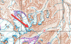
Here are a couple of examples from some scouting I did for a sheep trip a while back, what we had wondered about, and then what we saw when we got there. Map is 1:250K with 200' contour intervals.

In advance of the trip, we were planning to camp towards the N end of the red arrow and had wondered if we could get from where we were camped, over the high ridge to the south and into the drainage with the red X.
Once we got eyes on the terrain we decided although doable from a technical standpoint, the effort required and objective dangers were more than we wanted to take on. I'd rate the steepest terrain about about 45 degrees and class 3 including some loose scree slopes and chossy rock bands.

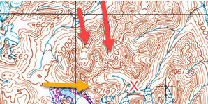
Another example from the same trip. The two red arrows show drainages that we explored trying to find the path of least resistance into the drainage with the red X. The two red arrow routes while doable, involved some sustained slopes up to 55 degrees on loose scree in the neighborhood of class 3. The yellow arrow route wound up being much easier and the best choice into the drainage.
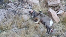
I'd post some photos from the field of what the terrain actually looked like...but then you'd all wind up in my spot next year

In advance of the trip, we were planning to camp towards the N end of the red arrow and had wondered if we could get from where we were camped, over the high ridge to the south and into the drainage with the red X.
Once we got eyes on the terrain we decided although doable from a technical standpoint, the effort required and objective dangers were more than we wanted to take on. I'd rate the steepest terrain about about 45 degrees and class 3 including some loose scree slopes and chossy rock bands.

Another example from the same trip. The two red arrows show drainages that we explored trying to find the path of least resistance into the drainage with the red X. The two red arrow routes while doable, involved some sustained slopes up to 55 degrees on loose scree in the neighborhood of class 3. The yellow arrow route wound up being much easier and the best choice into the drainage.
I'd post some photos from the field of what the terrain actually looked like...but then you'd all wind up in my spot next year
NABG Hunter
Lil-Rokslider
Regarding slope angle, 0 degrees is flat, 90 degrees is dead vertical. Regarding perceived slope angle, Most people think that 75 degrees is vertical and 90 degrees is overhanging. That is to say most people without a lot of mountaineering and/or climbing experience dramatically overestimate how steep terrain is.
In my experience, most hunters and hikers without mountaineering and climbing experience will dabble in class 3 terrain and on slopes up to about 45-50 degrees and that is usually about the end of their comfort level and for good reason. Getting steeper and/or more technical than that starts to open the door to serious consequences.
I agree with you completely. Even before I read this I thought 45 degrees is about max that most people will try to ascend. Even less when wearing hunting boots, a loaded daypack and a rifle. When you're on a "real 45 degree hill" it's pretty damn scary. I'm sure there will be some keyboard/chest pounders wanting to flame me for my statements. Oh, well. LOL.
recurveman
Lil-Rokslider
- Joined
- Jun 24, 2019
- Messages
- 100
FWIW - it never gets easier when you get there in person. I've had more than a few talks with myself about choices I made looking at google earth and maps. Those talks never resulted in me telling myself "what a great idea this was". Though frequently the talks end with "I'll never do this again". Stronger language is always used but just trying to keep it family friendly.
Similar threads
- Replies
- 9
- Views
- 229
Featured Video
Latest Articles
- TT#64 Josh Boyd Elk Hunting Strategies for Every Season
- Aaron Davidson of Gunwerks
- TT#63 Dirk Durham’s Art of Elk Calling
- BIG Buck Stories with the Dirty Giants Podcast
- TT#62 Brian Barney Hunting Bulls without Calling
- Hoyt Alpha AX-2 SD Review
- Kuiu Kenai vs Outdoor Vitals Vario Hooded Jacket Review
- Hoyt RX-9 Ultra Review
- Hunting Vampire Bucks & Building an Optics Kit
- Darton Sequel ST2 35 Review

