Help with this topo? Where would you hunt?

norman1wv

FNG
Joined
Jul 27, 2018
Messages
22
Location
Wv
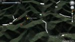
Hey guys. Here is sort of a topo map of the area that I'm hunting. I have been reading up on saddles, funnels, and other geographical features that deer use. I have also been reading up on "How to outsmart the wisest trophy whitetail" and other hunting related strategies. See my older thread titled "Help me get this monster deer" (something like that) if you want to update yourself with what I found in August..I have not been back to the rub-line as it has been rainy and the creek is up too high to cross and I recently found some huge tracks in another area that has sparked my interest. I have created a new thread in hopes of getting another person's view or what strategy they would use looking at the topo. Here is the key to the topo.

Red dot or circle = where I have seen deer (does)
Yellow circle = Huge rub-line found in august, really tore up, could be hogs as someone else suggested.
Green dot or circle = Saw an 8-pointer with perfect rack, still in velvet, after discovering the rub-line.
Blue fine circle = Thinking of scouting this area as it just "looks good to me" What do you think?
Grey dot = Huge tracks. Perfect impression in some semi-hard sand after rain. Tips of hooves are rounded, splayed apart like a
peace sign, two dots behind the track about 2 inches to the rear. (largest track I have ever seen from a whitetail) I
know this deer is old and very heavy!
Any and all tips will be greatly appreciated.
 

Attachments

  • 111.jpg
    111.jpg
    97.9 KB · Views: 165
As with all things, the answer is (for me at least) it depends... Time of day, wind direction, time of year (in relation to the rut), style of hunting (stand, spot & stalk, still hunt, calling?), density of cover, etc. If it were me, I'd generally get up on one of the ridges around your valley (yellow tack). Choose your ridge and direction of travel based on wind and thermals. Your does are using the ridges and the bucks will too, especially around the rut. Pick your style of hunting and get in a place that is conducive (open and high for glassing, along travel corridors for still or stand hunting) and be there at prime low light hours. Shoot buck and repeat.
 
Very nice reply! I pretty much have three locations that I feel would be productive. 1.- Where i found the huge track. There is a large natural spring near this area that deer drink from, as it is worn bare around it with hoof prints. Lots of old logging roads that act as corridors with a few scrapes, but didn't see any rubs. (not saying there are none, but I just haven't seen any). I like to sit above the corridor as thermals rise in the morning, carrying my scent above where I expect the deer to come from in hopes a trophy will walk past. .---- 2. is south of #1, still got logging roads but is located in a saddle with a slightly used trail that may be a trail a huge buck uses. I have seen does there. Few rubs. Doe bedding area. and #3 is also near #1 and is a doe bedding area with a very heavy used trail. Would be easy to fill a doe tag here and I may or may not have been sniffed out by a buck there. I say buck because this deer was kinda out on its own, came in from another direction, and was rather large. Issue? I read that wise old bucks normally will use another trail that parallels the trails that younger deer use and from what I have read, "deer are lazy animals". I personally don't agree or disagree with that statement, but to me its a no brainer that instead of going straight up a rock ciff, they would rather find an easier route, or walk over a saddle instead of across the tallest part of the ridge to conserve energy. I guess I should have asked the following: according to the map, do you see any obvious saddles or any places that deer would use to conserve energy as they travel?
 
View attachment 81006

I marked the spots i like in blue, now get out there n scout lol

------------------Invalid Attachment specified. If you followed a valid link, please notify the administrator----------(aka link don't work)

I must admit tho... a map don't really do a lot in the way of spotting good spots. I have studied this map for hours with nothing learned as I have walked most of what you see over the 40+ years of being alive. The idea of mapping the area got started after reading an article online. In a nut shell there were two guys. (guy 1 & guy 2).. guy 1 was always bagging larger bucks than guy 2 even tho he was disabled and couldn't walk much. (had a prosthetic leg after losing it falling out of a tree stand when he was younger) guy 2 wanted to know his secret. Guy 1 told him that he couldn't walk much, so he did all of his "scouting" using a topo map, that way he could see the funnels, draws, benches, and boundaries between bedding and feeding locations. He never scouted the area on foot, only looking at the map and deciding from that where to hunt. I guess it may have worked for him. Tug mentioned scouting, well bow season is in, its time to hunt. (although every time I go out it could be considered scouting as I have not really located any specific deer that I'm pursuing). Previously In another post I stated wild pigs may be responsible for the huge rub-line i found in august. (may still hold true), but funny there is a huge path that runs right beside the rubs. (pig trails?) Just beyond the rub-line is a spiderweb of trails going every direction. If the creek ever gets lower than waist deep, ill def have to check it out again, or maybe bite the bullet and spend all day hunting in below-freezing weather soaked to the bone from my waist down. (don't sound fun at all but would be worth it for a 200+ b&c whitetail. :-) Hope to eventually show a bruiser off! This area is well known for holding trophy bucks.
 
Just a little update, I think I got a good look at what made those tracks. While hearing activity just downwind of my location, I decided to just wing it and walk directly toward the commotion. Just as I got in sight the road that surrounds the point, I saw something move. There, for only 2 seconds max, was a beautiful 6 point with a perfect rack. Every tine looked to be the same length and girth. I would estimate a score of way less than 200. Couldn't have took him If I wanted tho, for some reason that morning I was often "off-balance" and having to step somewhere I didn't want to in order to stay on my feet. I stepped on a twig and off he bounded never raised his tail or blew. He just ran off. First buck I have seen this season.
 
My advice is to get out and hunt. Spend less time looking at maps and get out scouting actual woods.
Seems to me you are fairly new to whitetail hunting but have read a lot.
Experience is hard to replicate.

Don't worry about shooting a 200" B&C buck. There has probably been less than 5 living in your state in the past 50years. So not great odds...and the people that kill bucks that big in WV most likely are just lucky rifle hunters.

I would concentrate on having a good hunting season and taking a buck you are happy with...forget what other people talk about or pictures they post online. You are hunting for yourself...not someone else.

If I was going to give you advice on the map...I would get on ridges during the rut with climbers. Treat them as scout stands. Spots where you can see decent movement. Bounce around a lot and get a feel for the woods. Once you figure out how they move through using saddles or points...then hone your sits in to higher traffic areas.
 
No, I have been hunting for over 30 years. I have killed my fair share of deer, but now im getting older and only hunt for the larger trophy class bucks. I have seen many trophy size deer locally, so i know that they are around. This year I decided to take on some "tips".... what different decisions do young deer make vs older smarter bucks. I have had many opportunities this year to bag a 4 or 6 pointer, but I pass on those. Im currently on the trail of 2 eight pointers that would be trophy's for me as they are rather large bucks with large typical racks.
 
plus I found some rather strange rubs on trees back in august that puzzled me and got me all excited....
 
How much hunting pressure to you anticipate? If it's a heavily pressured area, all the best plans can go out the window once the orange army invades and starts pushing the deer around.
 
------------------Invalid Attachment specified. If you followed a valid link, please notify the administrator----------(aka link don't work)

I must admit tho... a map don't really do a lot in the way of spotting good spots. I have studied this map for hours with nothing learned as I have walked most of what you see over the 40+ years of being alive. The idea of mapping the area got started after reading an article online. In a nut shell there were two guys. (guy 1 & guy 2).. guy 1 was always bagging larger bucks than guy 2 even tho he was disabled and couldn't walk much. (had a prosthetic leg after losing it falling out of a tree stand when he was younger) guy 2 wanted to know his secret. Guy 1 told him that he couldn't walk much, so he did all of his "scouting" using a topo map, that way he could see the funnels, draws, benches, and boundaries between bedding and feeding locations. He never scouted the area on foot, only looking at the map and deciding from that where to hunt. I guess it may have worked for him. Tug mentioned scouting, well bow season is in, its time to hunt. (although every time I go out it could be considered scouting as I have not really located any specific deer that I'm pursuing). Previously In another post I stated wild pigs may be responsible for the huge rub-line i found in august. (may still hold true), but funny there is a huge path that runs right beside the rubs. (pig trails?) Just beyond the rub-line is a spiderweb of trails going every direction. If the creek ever gets lower than waist deep, ill def have to check it out again, or maybe bite the bullet and spend all day hunting in below-freezing weather soaked to the bone from my waist down. (don't sound fun at all but would be worth it for a 200+ b&c whitetail. :-) Hope to eventually show a bruiser off! This area is well known for holding trophy bucks.

You wouldn't be able to hunt all day in below freezing temps soaked to the bone from the waist down.
You could probably make it an hour before you lose fine motor skills...another hour and you are disoriented/confused.
At that point you may have another hour or so before your core temp is in the low 90s.
Your body will start to shut down blood flow to the extremities and you would eventually just die...probably before noon.

It would be very difficult to draw your bow on a 200" deer when you are shaking so bad you are almost convulsing...that could happen within a half hour or so. Seriously though...hypothermia is no joke.

Hopefully you can get out for 20-30 sits to help you learn the area. Hunting is the best tool for "scouting" and learning an area.

Good luck and be safe!
 
Back
Top