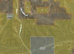
Help Understand Map

archp625

WKR
Joined
Jan 17, 2018
Messages
2,124
Location
St. Joseph, Missouri
Good morning everyone. I am a couple questions about Wyoming and Onx Maps. I got a county map so i know where the public roadways are in the county. The question I have it what are the single dotted lines on the map. I assume gravel roads? Can I navigate these roads off of public county roads? Also, not show in the pictures I see two dotted roads. What are these gravel two tracks.

One thing I have been reading and want to make sure I am correct, I can drive on gravel/.dirt roads off county roads if its BLM or State land. But once I hit private I cannot cross private to get to another BLM section. Is this correct? Thank you.
 

Attachments

  • Wyoming.jpg
    Wyoming.jpg
    160.7 KB · Views: 83
Joined
Apr 8, 2019
Messages
1,997
WY stand land site...

Yes you cannot cross private to access BLM state land. As far as roads its hit or miss and not much gravel. County maps are about the best info I can find...once you narrow down some areas I would call BLM office for your unit they can tell you if its accessible.
Good Luck!
 

bmf0713

WKR
Joined
Jan 25, 2017
Messages
319
You cannot cross private on two track roads. Pretty sure the single dash and double dash lines are the same, they just change with the different map veiws topo/sat/hyb. What i did when i went to wyoming was buy a map from mytopo and highlighted all the areas and roads i could drive on that way i didnt have to waste time tyring to figure out where i could and couldnt go when i got there.
 

plentycoupe

Lil-Rokslider
Joined
Jan 1, 2013
Messages
267
Good morning! Where did you buy the county map from? I'm about to do the same.
Thanks.
 

plentycoupe

Lil-Rokslider
Joined
Jan 1, 2013
Messages
267
You cannot cross private on two track roads. Pretty sure the single dash and double dash lines are the same, they just change with the different map veiws topo/sat/hyb. What i did when i went to wyoming was buy a map from mytopo and highlighted all the areas and roads i could drive on that way i didnt have to waste time tyring to figure out where i could and couldnt go when i got there.
What scale of a map did you buy from mytopo?
 

Ace531

FNG
Joined
Jul 9, 2019
Messages
51
Location
WI
Good morning! Where did you buy the county map from? I'm about to do the same.
Thanks.

Check out the county website where you are going. I will be going to antelope unit 108 in September, which is in Carbon County, and they had their county rec/trail maps for free for the Avenza map app (and in color too). Can download it (large file) and use it offline if necessary.
 

bmf0713

WKR
Joined
Jan 25, 2017
Messages
319
I bought county GIS maps first that were cheaper than mytopo but the place i was hunting had 3 counties so it would have been a pain in the ass to use 3 maps. mytopo focuses on just the unit your hunting. I was able to find public road info from county websites and making a couple calls.
 

wytx

WKR
Joined
Feb 2, 2017
Messages
2,322
Location
Wyoming
Not all the roads on the county's online map will be public, email or call the Road and Bridge Super. with specific questions on roads. Some will show emergency road access for private ranches.
Google the county name and GIS and the maps should come up if they have them online.
 

wytx

WKR
Joined
Feb 2, 2017
Messages
2,322
Location
Wyoming
It is possible that the BLM has road access through that private. As stated check with a local office if one is close .
You might just call the landowner and ask about access through, you may get lucky and they say yes. Look up their name on the county GIS landownership map .
 

blutooth

Lil-Rokslider
Joined
Sep 30, 2014
Messages
151
Location
WI
I’ve had the same question and here is how I’ve interpreted it by marking up your map

GREEN: I’m making the assumption this is the only county maintained road on the map. You can travel this road regardless of where it goes (definitely need to check a county map to confirm though)

BLUE: unmaintained 2 tracks on public land. You may be able to drive on them based on condition. I have read that some make be gated as well?

RED: unmaintained roads on private land. You can never travel here without written permission from the landowner.

I think green and red are straightforward which leaves the only real question as my interpretation of the blue. Am I correct that I can drive on any 2 track I see that is on public land so long as it is accessible? I know I can walk them, but is a motor vehicle allowed? I am assuming yes, but not 100%. I think this is essentially the same question as the OP?

85b7fd45ac6078a48d0563e7aa29fe69.jpg
 
OP
archp625

archp625

WKR
Joined
Jan 17, 2018
Messages
2,124
Location
St. Joseph, Missouri
Blutooth, you are correct about the green road being a county road. This came from the county map. I assume the same thing as you with the blue and red roads. I'm wanting clarification like you. Thanks for chiming in. Hopefully we can get our answer.
 

bmf0713

WKR
Joined
Jan 25, 2017
Messages
319
blutooth is correct on the boundaries. It’s kind of confusing and overwhelming for an out of stater only being able to see it on a map and taking their first trip out west. I was in that position a few years ago. But after you get out their and experience it you’ll understand better and it’s not that overwhelming.
 

197

FNG
Joined
Oct 3, 2016
Messages
44
Location
Virginia
I’ve had the same question and here is how I’ve interpreted it by marking up your map

GREEN: I’m making the assumption this is the only county maintained road on the map. You can travel this road regardless of where it goes (definitely need to check a county map to confirm though)

BLUE: unmaintained 2 tracks on public land. You may be able to drive on them based on condition. I have read that some make be gated as well?

RED: unmaintained roads on private land. You can never travel here without written permission from the landowner.

I think green and red are straightforward which leaves the only real question as my interpretation of the blue. Am I correct that I can drive on any 2 track I see that is on public land so long as it is accessible? I know I can walk them, but is a motor vehicle allowed? I am assuming yes, but not 100%. I think this is essentially the same question as the OP?

85b7fd45ac6078a48d0563e7aa29fe69.jpg
All of the blue should be fair game to drive on if it looks like a road, unless it is gated. These roads will be a mess if it rains, so probably only passable if it is dry. State land in Wyoming is typically open for access, but if used for another purpose could be gated. State land in Colorado is very different where much is not legally allowed to be accessed for hunting.
 

d90rick

Lil-Rokslider
Joined
Mar 13, 2015
Messages
146
i have also found that most of the time there is signage as to whether motorized travel is allowed or not
 
Top