Navigation
Install the app
How to install the app on iOS
Follow along with the video below to see how to install our site as a web app on your home screen.
Note: This feature may not be available in some browsers.
More options
Style variation
You are using an out of date browser. It may not display this or other websites correctly.
You should upgrade or use an alternative browser.
You should upgrade or use an alternative browser.
Get better at windcalls
- Thread starter THLR
- Start date
THLR
WKR
- Joined
- Mar 6, 2020
- Messages
- 322
Seems like I cropped a bit much:
Blue - Airpressure
Red - Temperature
Green - Terrain angle
All these corrections are applied to trajectory elevation.
Blue + red can be expressed as a single density altitude column.
Blue - Airpressure
Red - Temperature
Green - Terrain angle
All these corrections are applied to trajectory elevation.
Blue + red can be expressed as a single density altitude column.
THLR
WKR
- Joined
- Mar 6, 2020
- Messages
- 322
Here, found an abridged version for taping to the riflestock.
Airpressure also expressed as elevation gain/loss. In the terrain.
Vind 1 msec is base windvalue.
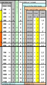
It's >10 years since I stopped doing it like this.
At the time I was using a S&B PMII 1/4 MOA turrets with P4F MRAD reticle. The only reason was that I got it half price due shit configuration. Hence my " clicks", I do not work MOA.
Airpressure also expressed as elevation gain/loss. In the terrain.
Vind 1 msec is base windvalue.

It's >10 years since I stopped doing it like this.
At the time I was using a S&B PMII 1/4 MOA turrets with P4F MRAD reticle. The only reason was that I got it half price due shit configuration. Hence my " clicks", I do not work MOA.
Last edited:
@THLR, thanks. It all makes sense, and at the same time feels cumbersome not having built something like this for myself...I imagine you are building cards ahead of time so you can simply read down, read over, and you have your adjusted solution so probably not so bad in practice? I admit my phone app is a crutch in the way of my learning and I'm interested in refining how I am able to approach this more efficiently in the field. I do like forms phone screenshot as screensaver...havent done that, but it makes great sense. At the moderate ranges I'm capable of I've found the "quick drops" to work well without any card/app at all: .5mil at 200, 1mil @ 300, 2mil at 400, etc, with 1click=20 yards under 300, 1click=10yards over 300; possibly with a correction factor of .1 or .2 mils for elevation change or a very different cartridge. This pretty consistently puts me within .1 of a good elevation solution and is very easy to have memorized and apply intuitively, but I'm not generally dealing with extreme angles, nor longer ranges where environmental factors make a bigger difference. It seems this is a "one card" for all locations, whereas other approaches seem to rely more on different cards for various DA's, or some such location/condition-specific method. Do you have a process flow or example of how you build this and apply it in the field? My impression is you have verbalized it in some of your videos, but I'm not sure I recall a "101" breakdown of it. I'm curious to hear the "THLR/Form collaboration on ballistic solutions for field shooting" podcast or video, my impression is you have a lot of overlap in your systems and thought processes, and at the same time some quite different ways of approaching it, so I'm curious to see it in action and compare & contrast and hear where you guys see the +'s and -'s.
Last edited:
THLR
WKR
- Joined
- Mar 6, 2020
- Messages
- 322
I suspect that could very quickly degenerate into the audio version of a circle jerk. However, I have been conditioned by my current employer to not to exclaim how much you suck, but rather take the long way in and explain how this is not conductive to an efficient workflow. Spend more time with the student in order to spend less time in my supervisor's office.I'm curious to hear the "THLR/Form collaboration on ballistic solutions for field shooting" podcast or video, my impression is you have a lot of overlap in your systems and thought processes,
The Swedish Method (named so because it is simple enough for a swede to use) is in the past for me, it was put in this thread simply to offer a perspective. It is not something I will revive or encourage.
Next episode, a little improvised in content due suspected equipment failure.
Last edited:
THLR
WKR
- Joined
- Mar 6, 2020
- Messages
- 322
Yes, sometimes I don't understand what people are doing...Also, “poo salsa”.
Here's a picture from a recent huntingfilm, imageframe where he breaks the shot
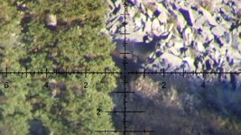
This is Triggercam the triggercam image (where he broke the shot) merged with the camera image where you see the bullet flick fur and strike the deer. Impact circled red, you can see the bright spot/image

This is the camera image cleaned, just to show how I aligned the two images.
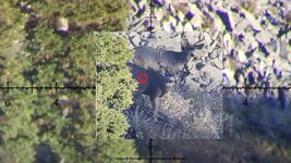
This is from one of the professionals (?) and I kinda see where the Rokslide influencer hate stems from.
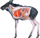
This is roughly the anatomy of ungulates. Learn to shoot and benefit from that knowledge. In my head, the purpose of shooting at the animal is to kill it as fast as possible and have a carcass with excellent food hygiene intact.
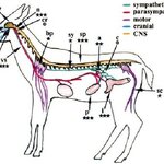
Now, some details on how to set up a BDC or default trajectory data:
Most nations have an online meteorological service with historical weather. Take out a 10 year sample for the area of interest, distill this data to relevant months and exclude night hours from temperature average ---> that's your temperature
Look at the average weather for same period, good or bad?
Look at the map, examine your topography.
Use a lookup table to find standard pressure for altitude. The actual pressure variation will typically be a 100 hPa window centered around this pressure number. I prefer set my pressure calibration slightly below this number as deer movment tends to be higher moving into or out of poor weather. If statistics says mostly good weather, you can go slightly above the number but I wouldn't. Don't worry about the pressure extremes as that will also bring weather ---> often pushing the animals into cover.
Huge elevation variations? Where do you have your long sightlines? The default trajectory usually gives you almost a 3000' elevation/ pressure window for the quicker shots.
Combine these two numbers if you prefer to work in Density Altitude.
You can do the same if you travel to a new area.
Last edited:
THLR
WKR
- Joined
- Mar 6, 2020
- Messages
- 322
Here's the last segment; equipment failure and unusually nice weather caused enough disruption to halt progress.
Basic weather knowledge...
Basic weather knowledge...
THLR
WKR
- Joined
- Mar 6, 2020
- Messages
- 322
What was supposed to be the finale of the series, but rather turned into a shitshow
Castle Rock
WKR
- Joined
- Mar 28, 2020
- Messages
- 1,713
That’s a real shame
Similar threads
- Replies
- 6
- Views
- 535
- Replies
- 1
- Views
- 189
- Replies
- 0
- Views
- 169
Featured Video
Latest Articles
- TT#64 Josh Boyd Elk Hunting Strategies for Every Season
- Aaron Davidson of Gunwerks
- TT#63 Dirk Durham’s Art of Elk Calling
- BIG Buck Stories with the Dirty Giants Podcast
- TT#62 Brian Barney Hunting Bulls without Calling
- Hoyt Alpha AX-2 SD Review
- Kuiu Kenai vs Outdoor Vitals Vario Hooded Jacket Review
- Hoyt RX-9 Ultra Review
- Hunting Vampire Bucks & Building an Optics Kit
- Darton Sequel ST2 35 Review
