Do you trust OnX?

Colby3

FNG
Joined
Mar 5, 2018
Location
Vermilion Ohio
The reason I ask this question is because of what I've found from our last years hunt. My son in law kept track of his steps/ millage on his FitBit watch on all our hunts. I kept track of our miles thru OnX tracks. We had 8 hunts. This is the the comparison between OnX and his FitBit and the difference.

day 1) OnX track 7.2 FitBit 9.8 2.6 diff

day 2) OnX track 4 FitBit 5.22 1.22 diff

day 3} OnX track 3.3 FitBit 4.38 1.08 diff

day 4} OnX track 7.7 Fit Bit 10.06 2.36 diff

day 5} OnX track 6.4 FitBit 10.04 3.64 diff

day 6 } OnX track 8.3 FitBit 13.53 5.23 diff

day 7} OnX track 8.1 FitBit 10.2 2.1 diff

Day 8} OnX track 8.1 FitBit 11.13 3.3 diff

I even laid a path over the OnX tracks and they were pretty close between the two. Going forward I'm thinking of adding about 20-30% to my planned hunt paths on OnX. Is there a more accurate way to figure hunt path miles?
 
I’ve never tracked my miles but I
Do know that OnX doesn’t always show land ownership properly, they say based on not having up to date maps of certain areas. It pays to know without the use of OnX what properties are in your area and at least roughly where they are.
 
I’ve often wondered if onX is able to calculate for elevation in there mileage, or if uses only horizontal distance travelled. Could be part of the difference?
 
I have an Onx chip in my gps. It seems to identify the boundaries of land but occasionaly it says unknown. If I really need to know I go to cadastral but I have found even that is off as much as 500 ft. That was measured from the surveyed corner to the cadastral corner.

If you think the fitbit is super accurate, you need to be on a horse where it counts all the horse steps. I have had a number days at 30,000 steps.
 
OnX Tracks linear miles by GPS and might have an algorithm for elevation gains and losses, but it will be an educated guess.

FitBit usually measures steps by vibration/ movement and stride length. Even if you measure your stride length on flat ground it will be different than rugged terrain.

Even if both use GPS tracking it is likely intermittent and not constant through the day.

Of the 2 I would trust OnX more. Either one is still a best guess and often is better at a comparative tool, i.e., a day with more or less mileage.

Pick one, stick with it, the fate of the free world won't hinge on it. Search and rescue will rely more on actual GPS location than mileage to or from somewhere.

In the end, it's a fun fact how many miles traveled, but frankly, mostly mental masturbation.

Pick one metric to keep it consistent as a comparison, know it won't be exact but close enough in 100 years, and if you need to pinpoint treasure, use GPS location rather than so many steps from the fancy rock.
 
The reason I ask this question is because of what I've found from our last years hunt. My son in law kept track of his steps/ millage on his FitBit watch on all our hunts. I kept track of our miles thru OnX tracks. We had 8 hunts. This is the the comparison between OnX and his FitBit and the difference.

day 1) OnX track 7.2 FitBit 9.8 2.6 diff

day 2) OnX track 4 FitBit 5.22 1.22 diff

day 3} OnX track 3.3 FitBit 4.38 1.08 diff

day 4} OnX track 7.7 Fit Bit 10.06 2.36 diff

day 5} OnX track 6.4 FitBit 10.04 3.64 diff

day 6 } OnX track 8.3 FitBit 13.53 5.23 diff

day 7} OnX track 8.1 FitBit 10.2 2.1 diff

Day 8} OnX track 8.1 FitBit 11.13 3.3 diff

I even laid a path over the OnX tracks and they were pretty close between the two. Going forward I'm thinking of adding about 20-30% to my planned hunt paths on OnX. Is there a more accurate way to figure hunt path miles?
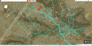
Agree with others who said, OnX is more accurate. Fit bits definitely over count and are very sensitive to all movements, not just over-ground distances.
 
Have you ever looked at an OnX track?
I could very well be wrong regarding the intermittent tracking and perhaps that has changed. Perhaps @onX Hunt could answer better than I.

Again, I could be wrong, but with the battery drain caused by constant GPS tracking, it is my understanding the data points are intermittent (though I do not know the intermittent time frame) and then the software creates a track that looks constant, connecting the intermittent data points.

Again, my sincerest apologies if I am incorrect.
 
When I had both OnX and Gaia I did track distance comparisons. They were always close enough to call them the same. Maybe a tenth difference.
 
Back
Top