Standard sea level pressure and temperature is 29.92” Hg, and 59* F. The standard lapse rate per 1000 ft. of elevation gain is approximately -1.0” Hg for pressure and -3.5*F for temperature.
If I do not have a weather meter providing actual atmospheric data, I do the following:
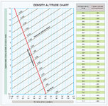
I am content with entering the attached chart at my actual elevation above sea level (standard pressure altitude), following the diagonal line to the actual temperature, and going straight across to read the DA. This is the DA I enter in the GeoBallistic app I use. With a normal barometric pressure range of say 29.70” Hg to 30.30” Hg ( not extreme high or low pressure) I am off the actual pressure altitude by less than 200-400 ft by entering the chart at standard pressure.
If you want to get more accurate you could use the “pressure altitude conversion factor” before entering the chart.
For example:
I am at an actual 8500’ elevation and it is 65*F. I simply enter the chart at 8500’ pressure altitude, stop at 65*F, follow straight to the left and read a DA of 10,600’.
If I know the barometric pressure is actually 30.20” Hg in the area (.28” above standard) and I want to be more accurate in my calculations, I use the conversion factor of -257’. Enter the chart at 8243’ (8500’ - 257’). Stop at 65*F, follow straight to the left and read a DA of 10,343’. I would find an accurate local barometric pressure by obtaining pressure from several surrounding airports.
Even for a 1000 yard shot, the app’ generates 7.2 MIL elevation required for both the estimated 10,600’ DA and the actual 10343’ DA.