Navigation
Install the app
How to install the app on iOS
Follow along with the video below to see how to install our site as a web app on your home screen.
Note: This feature may not be available in some browsers.
More options
Style variation
You are using an out of date browser. It may not display this or other websites correctly.
You should upgrade or use an alternative browser.
You should upgrade or use an alternative browser.
OnX winter/summer range
- Thread starter sivart
- Start date
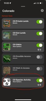
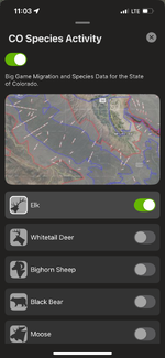
Yes, under layers select species activityDoes Onx have a layer to show elk winter and summer ranges? I cannot find it. I know that Gohunt does.
Attachments
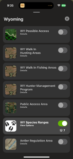
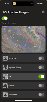
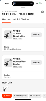
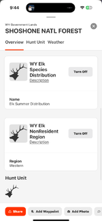
We do have Species Range data for Wyoming. The dataset we get from the state of WYoming is a little different than the dataset we get from Colorado, but if you open your Wyoming layers and scroll down, you'll be able to turn on the WY Species Ranges layer. From there, click on View Options and select the Elk sublayer to see the data for elk.
Attachments
When will the Teton Wilderness areas of western WY get updated maps? its been 4 years or more where everything in your satellite images is covered in snow. Ive submitted multiple reports asking for an update for years, and never hear anything back, and dont see any progress. How hard is it for updated imagery to be used, or at least old imagery from summer. Cause mid-winter images are pointlessWe do have Species Range data for Wyoming. The dataset we get from the state of WYoming is a little different than the dataset we get from Colorado, but if you open your Wyoming layers and scroll down, you'll be able to turn on the WY Species Ranges layer. From there, click on View Options and select the Elk sublayer to see the data for elk.
So that just shows the elk range in all 4 seasons?We do have Species Range data for Wyoming. The dataset we get from the state of WYoming is a little different than the dataset we get from Colorado, but if you open your Wyoming layers and scroll down, you'll be able to turn on the WY Species Ranges layer. From there, click on View Options and select the Elk sublayer to see the data for elk.
Our last base imagery update for Wyoming was in November of 2024. The imagery set for this update was mostly flown in the summer of 2021. It can be difficult to get snow free imagery for high elevation areas because the window for that is relatively short and our imagery partners don’t always prioritize that aspect when planning their flights. The imagery for the Teton Wilderness looks like it was flown in June of 2021 and has some snow coverage, but nowhere near what you would expect to see for this range in mid-winter. We’re currently working on another update for WY that should be live before hunting seasons kick off, but we can’t promise there won’t be snow in this set. If the imagery is obscured by snow we’ll selectively patch in older imagery to try to get the best overall representation we can.When will the Teton Wilderness areas of western WY get updated maps? its been 4 years or more where everything in your satellite images is covered in snow. Ive submitted multiple reports asking for an update for years, and never hear anything back, and dont see any progress. How hard is it for updated imagery to be used, or at least old imagery from summer. Cause mid-winter images are pointless
If you tap on the map with the WY Species Ranges layer turned on, the query card will tell you if it is winter or summer range.So that just shows the elk range in all 4 seasons?
Attachments
Wanted to update you that we just released updated imagery for Wyoming. We think this new imagery is a good improvement over our previous imagery.When will the Teton Wilderness areas of western WY get updated maps? its been 4 years or more where everything in your satellite images is covered in snow. Ive submitted multiple reports asking for an update for years, and never hear anything back, and dont see any progress. How hard is it for updated imagery to be used, or at least old imagery from summer. Cause mid-winter images are pointless
Similar threads
- Replies
- 3
- Views
- 106
- Replies
- 4
- Views
- 725
- Replies
- 37
- Views
- 3K
Latest posts
-
-
-
-
Savage Axis (&2) question - converting a short action to a long action?
- Latest: bojangles808
-
Featured Video
Latest Articles
- TT#64 Josh Boyd Elk Hunting Strategies for Every Season
- Aaron Davidson of Gunwerks
- TT#63 Dirk Durham’s Art of Elk Calling
- BIG Buck Stories with the Dirty Giants Podcast
- TT#62 Brian Barney Hunting Bulls without Calling
- Hoyt Alpha AX-2 SD Review
- Kuiu Kenai vs Outdoor Vitals Vario Hooded Jacket Review
- Hoyt RX-9 Ultra Review
- Hunting Vampire Bucks & Building an Optics Kit
- Darton Sequel ST2 35 Review

